You are here: Home > Network List > MN - MEDNET Project Stations List
> Station DIVS Divcibare,Serbia > Earthquake Result Viewer
DIVS Divcibare,Serbia - Earthquake Result Viewer

| Earthquake location: |
Kuril Islands |
| Earthquake latitude/longitude: |
49.4/155.9 |
| Earthquake time(UTC): |
2012/07/20 (202) 06:10:25 GMT |
| Earthquake Depth: |
19 km |
| Earthquake Magnitude: |
5.7 MB, 5.7 MS, 6.0 MW, 6.1 MW |
| Earthquake Catalog/Contributor: |
WHDF/NEIC |
|
| Network: |
MN MEDNET Project |
| Station: |
DIVS Divcibare,Serbia |
| Lat/Lon: |
44.10 N/19.99 E |
| Elevation: |
1000 m |
|
| Distance: |
79.2 deg |
| Az: |
329.319 deg |
| Baz: |
27.556 deg |
| Ray Param: |
0.049093723 |
| Estimated Moho Depth: |
21.25 km |
| Estimated Crust Vp/Vs: |
2.04 |
| Assumed Crust Vp: |
6.264 km/s |
| Estimated Crust Vs: |
3.074 km/s |
| Estimated Crust Poisson's Ratio: |
0.34 |
|
| Radial Match: |
92.15987 % |
| Radial Bump: |
400 |
| Transverse Match: |
76.98847 % |
| Transverse Bump: |
400 |
| SOD ConfigId: |
468427 |
| Insert Time: |
2013-02-21 22:22:44.337 +0000 |
| GWidth: |
2.5 |
| Max Bumps: |
400 |
| Tol: |
0.001 |
|
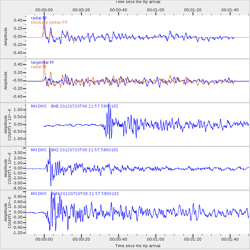
Signal To Noise
| Channel | StoN | STA | LTA |
| MN:DIVS: :BHZ:20120720T06:21:57.586016Z | 44.151833 | 1.4143396E-6 | 3.2033544E-8 |
| MN:DIVS: :BHN:20120720T06:21:57.586016Z | 23.141504 | 5.0940656E-7 | 2.2012681E-8 |
| MN:DIVS: :BHE:20120720T06:21:57.586016Z | 10.572545 | 4.386108E-7 | 4.148583E-8 |
| Arrivals |
| Ps | 3.6 SECOND |
| PpPs | 10 SECOND |
| PsPs/PpSs | 14 SECOND |


