You are here: Home > Network List > TA - USArray Transportable Network (new EarthScope stations) Stations List
> Station I04A Tendick Farm, Oakridge, OR, USA > Earthquake Result Viewer
I04A Tendick Farm, Oakridge, OR, USA - Earthquake Result Viewer

| Earthquake location: |
Kuril Islands |
| Earthquake latitude/longitude: |
49.4/155.9 |
| Earthquake time(UTC): |
2012/07/20 (202) 06:10:25 GMT |
| Earthquake Depth: |
19 km |
| Earthquake Magnitude: |
5.7 MB, 5.7 MS, 6.0 MW, 6.1 MW |
| Earthquake Catalog/Contributor: |
WHDF/NEIC |
|
| Network: |
TA USArray Transportable Network (new EarthScope stations) |
| Station: |
I04A Tendick Farm, Oakridge, OR, USA |
| Lat/Lon: |
43.79 N/122.41 W |
| Elevation: |
731 m |
|
| Distance: |
53.8 deg |
| Az: |
62.617 deg |
| Baz: |
306.779 deg |
| Ray Param: |
0.06583543 |
| Estimated Moho Depth: |
10.5 km |
| Estimated Crust Vp/Vs: |
2.04 |
| Assumed Crust Vp: |
6.522 km/s |
| Estimated Crust Vs: |
3.197 km/s |
| Estimated Crust Poisson's Ratio: |
0.34 |
|
| Radial Match: |
88.44819 % |
| Radial Bump: |
400 |
| Transverse Match: |
68.35329 % |
| Transverse Bump: |
400 |
| SOD ConfigId: |
468427 |
| Insert Time: |
2013-02-21 22:28:35.078 +0000 |
| GWidth: |
2.5 |
| Max Bumps: |
400 |
| Tol: |
0.001 |
|
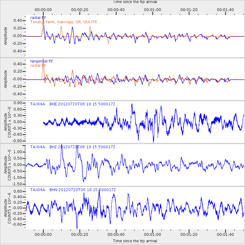
Signal To Noise
| Channel | StoN | STA | LTA |
| TA:I04A: :BHZ:20120720T06:19:15.500017Z | 3.0108452 | 2.8150916E-7 | 9.349838E-8 |
| TA:I04A: :BHN:20120720T06:19:15.500017Z | 1.1157293 | 1.314294E-7 | 1.1779685E-7 |
| TA:I04A: :BHE:20120720T06:19:15.500017Z | 1.5257636 | 1.242031E-7 | 8.140389E-8 |
| Arrivals |
| Ps | 1.8 SECOND |
| PpPs | 4.7 SECOND |
| PsPs/PpSs | 6.4 SECOND |


