You are here: Home > Network List > TA - USArray Transportable Network (new EarthScope stations) Stations List
> Station C35A Jirik Farms, Max, MN, USA > Earthquake Result Viewer
C35A Jirik Farms, Max, MN, USA - Earthquake Result Viewer
| Earthquake location: |
Kuril Islands |
| Earthquake latitude/longitude: |
49.4/155.9 |
| Earthquake time(UTC): |
2012/07/20 (202) 06:10:25 GMT |
| Earthquake Depth: |
19 km |
| Earthquake Magnitude: |
5.7 MB, 5.7 MS, 6.0 MW, 6.1 MW |
| Earthquake Catalog/Contributor: |
WHDF/NEIC |
|
| Network: |
TA USArray Transportable Network (new EarthScope stations) |
| Station: |
C35A Jirik Farms, Max, MN, USA |
| Lat/Lon: |
47.70 N/93.98 W |
| Elevation: |
426 m |
|
| Distance: |
66.0 deg |
| Az: |
43.967 deg |
| Baz: |
317.829 deg |
| Ray Param: |
0.05787783 |
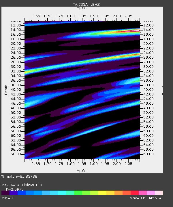
| Estimated Moho Depth: |
14.0 km |
| Estimated Crust Vp/Vs: |
2.10 |
| Assumed Crust Vp: |
6.571 km/s |
| Estimated Crust Vs: |
3.133 km/s |
| Estimated Crust Poisson's Ratio: |
0.35 |
|
| Radial Match: |
81.85736 % |
| Radial Bump: |
400 |
| Transverse Match: |
70.32099 % |
| Transverse Bump: |
400 |
| SOD ConfigId: |
468427 |
| Insert Time: |
2013-02-21 22:35:27.193 +0000 |
| GWidth: |
2.5 |
| Max Bumps: |
400 |
| Tol: |
0.001 |
|
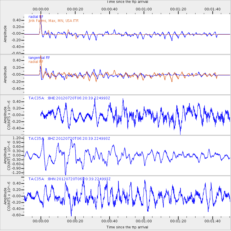
Signal To Noise
| Channel | StoN | STA | LTA |
| TA:C35A: :BHZ:20120720T06:20:39.224993Z | 3.6974812 | 6.039483E-7 | 1.6334047E-7 |
| TA:C35A: :BHN:20120720T06:20:39.224993Z | 2.7225301 | 1.9576073E-7 | 7.1903976E-8 |
| TA:C35A: :BHE:20120720T06:20:39.224993Z | 1.3916751 | 1.995724E-7 | 1.4340445E-7 |
| Arrivals |
| Ps | 2.4 SECOND |
| PpPs | 6.4 SECOND |
| PsPs/PpSs | 8.8 SECOND |


