You are here: Home > Network List > TA - USArray Transportable Network (new EarthScope stations) Stations List
> Station Q39A Willow Grove Farm, Nelson, MO, USA > Earthquake Result Viewer
Q39A Willow Grove Farm, Nelson, MO, USA - Earthquake Result Viewer
| Earthquake location: |
Kuril Islands |
| Earthquake latitude/longitude: |
49.4/155.9 |
| Earthquake time(UTC): |
2012/07/20 (202) 06:10:25 GMT |
| Earthquake Depth: |
19 km |
| Earthquake Magnitude: |
5.7 MB, 5.7 MS, 6.0 MW, 6.1 MW |
| Earthquake Catalog/Contributor: |
WHDF/NEIC |
|
| Network: |
TA USArray Transportable Network (new EarthScope stations) |
| Station: |
Q39A Willow Grove Farm, Nelson, MO, USA |
| Lat/Lon: |
39.05 N/92.98 W |
| Elevation: |
225 m |
|
| Distance: |
73.0 deg |
| Az: |
49.417 deg |
| Baz: |
320.427 deg |
| Ray Param: |
0.053251613 |
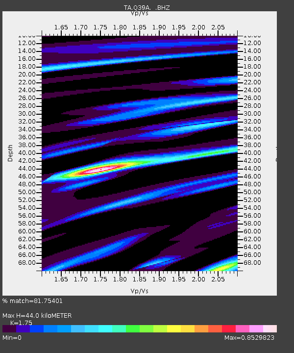
| Estimated Moho Depth: |
44.0 km |
| Estimated Crust Vp/Vs: |
1.75 |
| Assumed Crust Vp: |
6.498 km/s |
| Estimated Crust Vs: |
3.713 km/s |
| Estimated Crust Poisson's Ratio: |
0.26 |
|
| Radial Match: |
81.75401 % |
| Radial Bump: |
327 |
| Transverse Match: |
69.5856 % |
| Transverse Bump: |
400 |
| SOD ConfigId: |
468427 |
| Insert Time: |
2013-02-21 22:43:12.107 +0000 |
| GWidth: |
2.5 |
| Max Bumps: |
400 |
| Tol: |
0.001 |
|

Signal To Noise
| Channel | StoN | STA | LTA |
| TA:Q39A: :BHZ:20120720T06:21:22.500017Z | 3.896714 | 6.326289E-7 | 1.6234932E-7 |
| TA:Q39A: :BHN:20120720T06:21:22.500017Z | 3.2190893 | 2.470512E-7 | 7.674568E-8 |
| TA:Q39A: :BHE:20120720T06:21:22.500017Z | 1.7730315 | 2.1471993E-7 | 1.2110328E-7 |
| Arrivals |
| Ps | 5.3 SECOND |
| PpPs | 18 SECOND |
| PsPs/PpSs | 23 SECOND |


