You are here: Home > Network List > TA - USArray Transportable Network (new EarthScope stations) Stations List
> Station O40A La Belle, MO, USA > Earthquake Result Viewer
O40A La Belle, MO, USA - Earthquake Result Viewer
*The percent match for this event was below the threshold and hence no stack was calculated.
| Earthquake location: |
Kuril Islands |
| Earthquake latitude/longitude: |
49.4/155.9 |
| Earthquake time(UTC): |
2012/07/20 (202) 06:10:25 GMT |
| Earthquake Depth: |
19 km |
| Earthquake Magnitude: |
5.7 MB, 5.7 MS, 6.0 MW, 6.1 MW |
| Earthquake Catalog/Contributor: |
WHDF/NEIC |
|
| Network: |
TA USArray Transportable Network (new EarthScope stations) |
| Station: |
O40A La Belle, MO, USA |
| Lat/Lon: |
40.12 N/91.87 W |
| Elevation: |
206 m |
|
| Distance: |
72.7 deg |
| Az: |
48.015 deg |
| Baz: |
320.714 deg |
| Ray Param: |
$rayparam |
*The percent match for this event was below the threshold and hence was not used in the summary stack. |
|
| Radial Match: |
79.92408 % |
| Radial Bump: |
400 |
| Transverse Match: |
66.30689 % |
| Transverse Bump: |
400 |
| SOD ConfigId: |
468427 |
| Insert Time: |
2013-02-21 22:44:09.865 +0000 |
| GWidth: |
2.5 |
| Max Bumps: |
400 |
| Tol: |
0.001 |
|
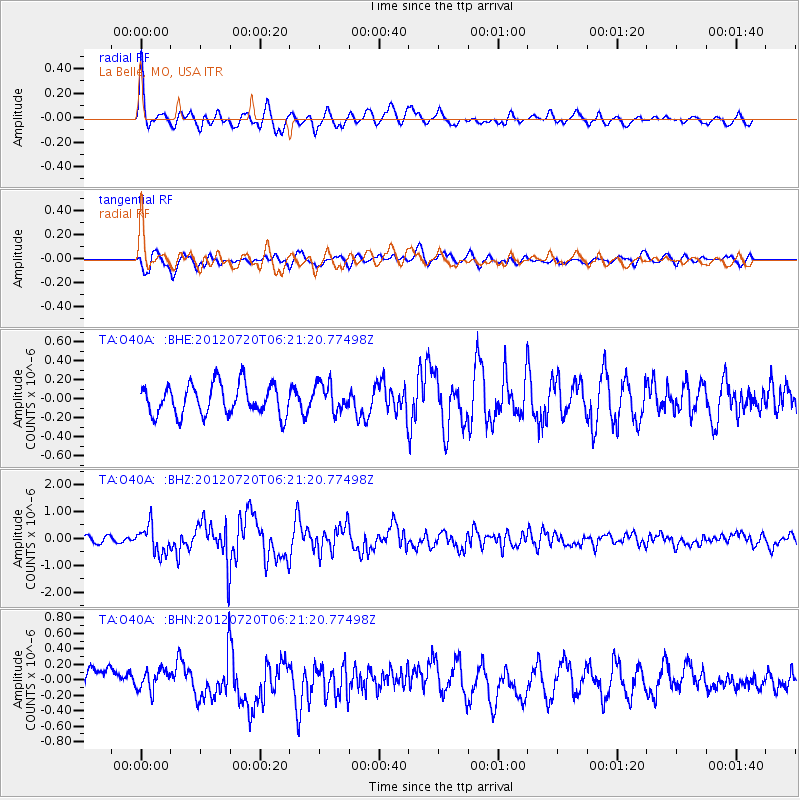
Signal To Noise
| Channel | StoN | STA | LTA |
| TA:O40A: :BHZ:20120720T06:21:20.77498Z | 2.9630198 | 5.130455E-7 | 1.7314954E-7 |
| TA:O40A: :BHN:20120720T06:21:20.77498Z | 0.9982885 | 1.3662022E-7 | 1.3685444E-7 |
| TA:O40A: :BHE:20120720T06:21:20.77498Z | 0.9319972 | 1.4915804E-7 | 1.600413E-7 |
| Arrivals |
| Ps | |
| PpPs | |
| PsPs/PpSs | |


