You are here: Home > Network List > TA - USArray Transportable Network (new EarthScope stations) Stations List
> Station V39A Pettigrew, AR, USA > Earthquake Result Viewer
V39A Pettigrew, AR, USA - Earthquake Result Viewer
*The percent match for this event was below the threshold and hence no stack was calculated.
| Earthquake location: |
Kuril Islands |
| Earthquake latitude/longitude: |
49.4/155.9 |
| Earthquake time(UTC): |
2012/07/20 (202) 06:10:25 GMT |
| Earthquake Depth: |
19 km |
| Earthquake Magnitude: |
5.7 MB, 5.7 MS, 6.0 MW, 6.1 MW |
| Earthquake Catalog/Contributor: |
WHDF/NEIC |
|
| Network: |
TA USArray Transportable Network (new EarthScope stations) |
| Station: |
V39A Pettigrew, AR, USA |
| Lat/Lon: |
35.84 N/93.64 W |
| Elevation: |
744 m |
|
| Distance: |
75.2 deg |
| Az: |
51.959 deg |
| Baz: |
320.718 deg |
| Ray Param: |
$rayparam |
*The percent match for this event was below the threshold and hence was not used in the summary stack. |
|
| Radial Match: |
78.4727 % |
| Radial Bump: |
400 |
| Transverse Match: |
59.27533 % |
| Transverse Bump: |
400 |
| SOD ConfigId: |
468427 |
| Insert Time: |
2013-02-21 22:45:52.115 +0000 |
| GWidth: |
2.5 |
| Max Bumps: |
400 |
| Tol: |
0.001 |
|
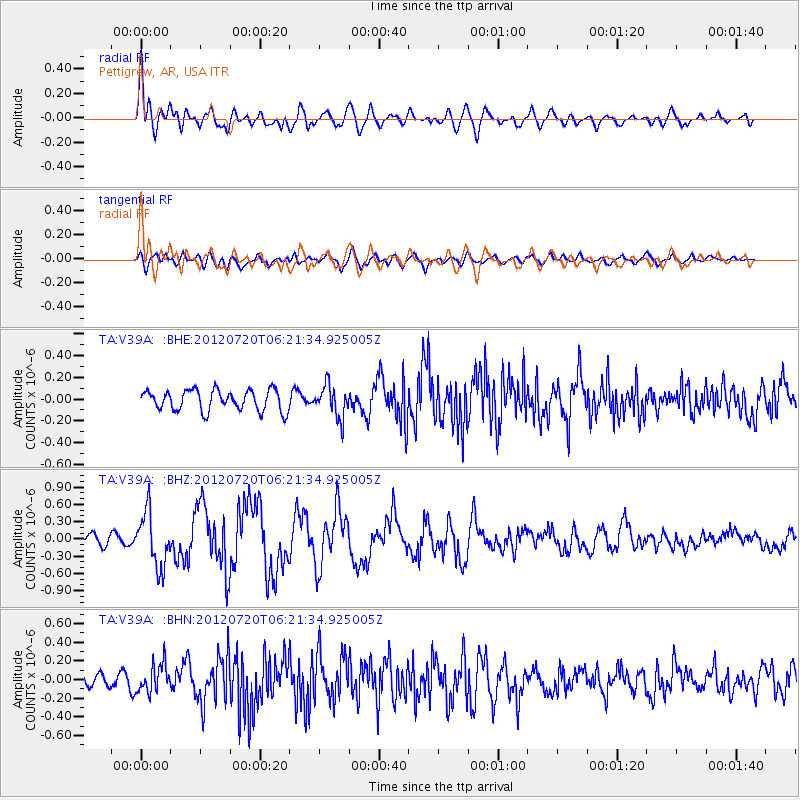
Signal To Noise
| Channel | StoN | STA | LTA |
| TA:V39A: :BHZ:20120720T06:21:34.925005Z | 5.9167256 | 4.696754E-7 | 7.938097E-8 |
| TA:V39A: :BHN:20120720T06:21:34.925005Z | 2.0927532 | 1.5150113E-7 | 7.239321E-8 |
| TA:V39A: :BHE:20120720T06:21:34.925005Z | 1.5435683 | 1.462616E-7 | 9.475551E-8 |
| Arrivals |
| Ps | |
| PpPs | |
| PsPs/PpSs | |


