You are here: Home > Network List > TA - USArray Transportable Network (new EarthScope stations) Stations List
> Station 348A Jackson, AL, USA > Earthquake Result Viewer
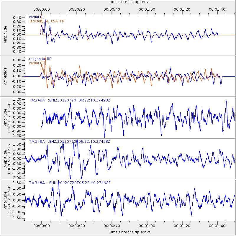
348A Jackson, AL, USA - Earthquake Result Viewer
*The percent match for this event was below the threshold and hence no stack was calculated.
| Earthquake location: |
Kuril Islands |
| Earthquake latitude/longitude: |
49.4/155.9 |
| Earthquake time(UTC): |
2012/07/20 (202) 06:10:25 GMT |
| Earthquake Depth: |
19 km |
| Earthquake Magnitude: |
5.7 MB, 5.7 MS, 6.0 MW, 6.1 MW |
| Earthquake Catalog/Contributor: |
WHDF/NEIC |
|
| Network: |
TA USArray Transportable Network (new EarthScope stations) |
| Station: |
348A Jackson, AL, USA |
| Lat/Lon: |
31.41 N/87.90 W |
| Elevation: |
57 m |
|
| Distance: |
81.6 deg |
| Az: |
50.854 deg |
| Baz: |
323.665 deg |
| Ray Param: |
$rayparam |
*The percent match for this event was below the threshold and hence was not used in the summary stack. |
|
| Radial Match: |
73.21057 % |
| Radial Bump: |
400 |
| Transverse Match: |
72.61279 % |
| Transverse Bump: |
400 |
| SOD ConfigId: |
468427 |
| Insert Time: |
2013-02-21 22:50:44.224 +0000 |
| GWidth: |
2.5 |
| Max Bumps: |
400 |
| Tol: |
0.001 |
|
Signal To Noise
| Channel | StoN | STA | LTA |
| TA:348A: :BHZ:20120720T06:22:10.27498Z | 4.2457957 | 7.038001E-7 | 1.65764E-7 |
| TA:348A: :BHN:20120720T06:22:10.27498Z | 0.880886 | 2.7334693E-7 | 3.1030908E-7 |
| TA:348A: :BHE:20120720T06:22:10.27498Z | 1.2003547 | 3.754164E-7 | 3.1275457E-7 |
| Arrivals |
| Ps | |
| PpPs | |
| PsPs/PpSs | |


