You are here: Home > Network List > TA - USArray Transportable Network (new EarthScope stations) Stations List
> Station X41A Kaden, Bauxite, AR, USA > Earthquake Result Viewer
X41A Kaden, Bauxite, AR, USA - Earthquake Result Viewer
| Earthquake location: |
Kuril Islands |
| Earthquake latitude/longitude: |
49.4/155.9 |
| Earthquake time(UTC): |
2012/07/20 (202) 06:10:25 GMT |
| Earthquake Depth: |
19 km |
| Earthquake Magnitude: |
5.7 MB, 5.7 MS, 6.0 MW, 6.1 MW |
| Earthquake Catalog/Contributor: |
WHDF/NEIC |
|
| Network: |
TA USArray Transportable Network (new EarthScope stations) |
| Station: |
X41A Kaden, Bauxite, AR, USA |
| Lat/Lon: |
34.49 N/92.51 W |
| Elevation: |
102 m |
|
| Distance: |
76.8 deg |
| Az: |
52.084 deg |
| Baz: |
321.398 deg |
| Ray Param: |
0.05073772 |
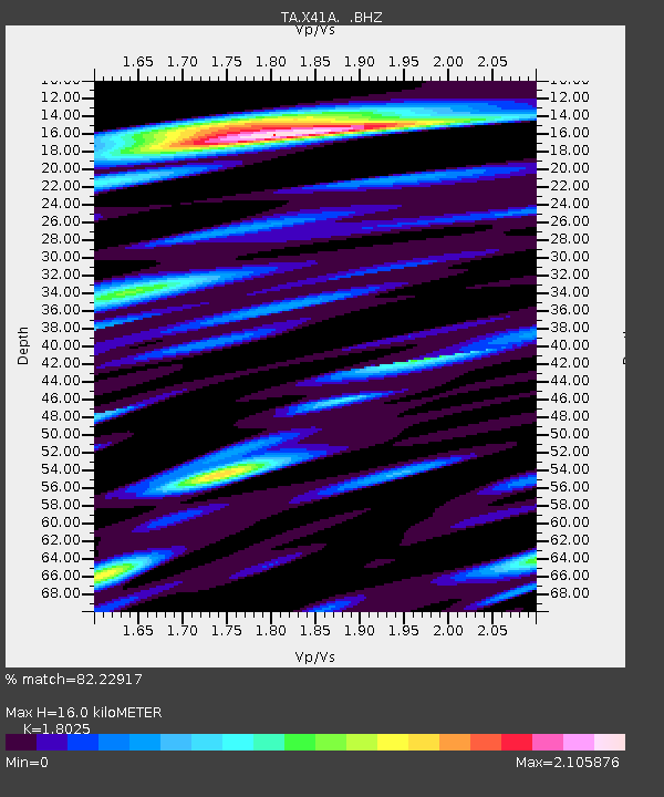
| Estimated Moho Depth: |
16.0 km |
| Estimated Crust Vp/Vs: |
1.80 |
| Assumed Crust Vp: |
6.498 km/s |
| Estimated Crust Vs: |
3.605 km/s |
| Estimated Crust Poisson's Ratio: |
0.28 |
|
| Radial Match: |
82.22917 % |
| Radial Bump: |
400 |
| Transverse Match: |
66.6295 % |
| Transverse Bump: |
400 |
| SOD ConfigId: |
468427 |
| Insert Time: |
2013-02-21 22:54:15.141 +0000 |
| GWidth: |
2.5 |
| Max Bumps: |
400 |
| Tol: |
0.001 |
|
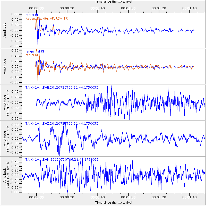
Signal To Noise
| Channel | StoN | STA | LTA |
| TA:X41A: :BHZ:20120720T06:21:44.175005Z | 5.210101 | 4.2363718E-7 | 8.131074E-8 |
| TA:X41A: :BHN:20120720T06:21:44.175005Z | 3.2223592 | 2.5979546E-7 | 8.0622755E-8 |
| TA:X41A: :BHE:20120720T06:21:44.175005Z | 1.9541914 | 1.6844533E-7 | 8.619694E-8 |
| Arrivals |
| Ps | 2.0 SECOND |
| PpPs | 6.7 SECOND |
| PsPs/PpSs | 8.7 SECOND |


