You are here: Home > Network List > TA - USArray Transportable Network (new EarthScope stations) Stations List
> Station X44A Crenshaw, MS, USA > Earthquake Result Viewer
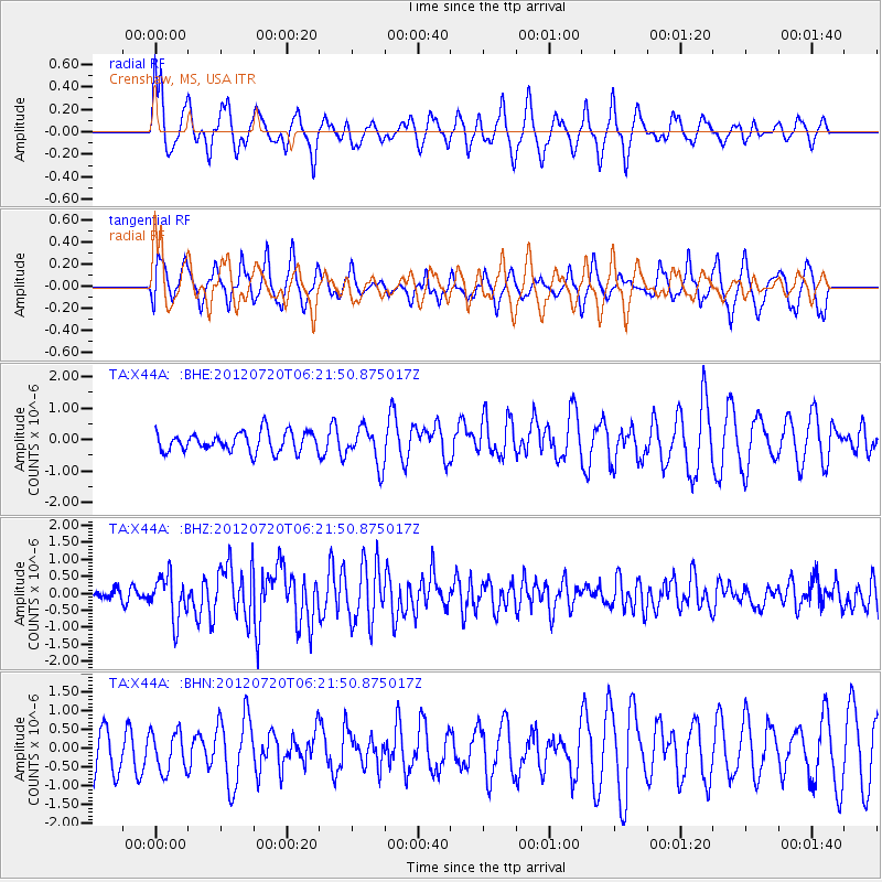
X44A Crenshaw, MS, USA - Earthquake Result Viewer
*The percent match for this event was below the threshold and hence no stack was calculated.
| Earthquake location: |
Kuril Islands |
| Earthquake latitude/longitude: |
49.4/155.9 |
| Earthquake time(UTC): |
2012/07/20 (202) 06:10:25 GMT |
| Earthquake Depth: |
19 km |
| Earthquake Magnitude: |
5.7 MB, 5.7 MS, 6.0 MW, 6.1 MW |
| Earthquake Catalog/Contributor: |
WHDF/NEIC |
|
| Network: |
TA USArray Transportable Network (new EarthScope stations) |
| Station: |
X44A Crenshaw, MS, USA |
| Lat/Lon: |
34.50 N/90.15 W |
| Elevation: |
109 m |
|
| Distance: |
78.0 deg |
| Az: |
50.505 deg |
| Baz: |
322.388 deg |
| Ray Param: |
$rayparam |
*The percent match for this event was below the threshold and hence was not used in the summary stack. |
|
| Radial Match: |
51.28619 % |
| Radial Bump: |
400 |
| Transverse Match: |
55.615314 % |
| Transverse Bump: |
387 |
| SOD ConfigId: |
468427 |
| Insert Time: |
2013-02-21 22:54:37.628 +0000 |
| GWidth: |
2.5 |
| Max Bumps: |
400 |
| Tol: |
0.001 |
|
Signal To Noise
| Channel | StoN | STA | LTA |
| TA:X44A: :BHZ:20120720T06:21:50.875017Z | 3.515851 | 6.4303833E-7 | 1.8289693E-7 |
| TA:X44A: :BHN:20120720T06:21:50.875017Z | 0.7327589 | 5.271925E-7 | 7.194625E-7 |
| TA:X44A: :BHE:20120720T06:21:50.875017Z | 1.8648715 | 5.887213E-7 | 3.1569002E-7 |
| Arrivals |
| Ps | |
| PpPs | |
| PsPs/PpSs | |


