You are here: Home > Network List > G - GEOSCOPE Stations List
> Station SSB2 Saint Sauveur Badole, France > Earthquake Result Viewer
SSB2 Saint Sauveur Badole, France - Earthquake Result Viewer
| Earthquake location: |
Near Coast Of Northern Calif. |
| Earthquake latitude/longitude: |
40.4/-124.3 |
| Earthquake time(UTC): |
1992/04/25 (116) 18:06:04 GMT |
| Earthquake Depth: |
15 km |
| Earthquake Magnitude: |
6.4 MB, 7.1 MS |
| Earthquake Catalog/Contributor: |
WHDF/NEIC |
|
| Network: |
G GEOSCOPE |
| Station: |
SSB2 Saint Sauveur Badole, France |
| Lat/Lon: |
45.28 N/4.54 E |
| Elevation: |
700 m |
|
| Distance: |
83.2 deg |
| Az: |
33.621 deg |
| Baz: |
323.189 deg |
| Ray Param: |
0.046350777 |
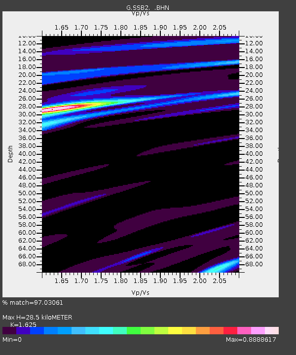
| Estimated Moho Depth: |
28.5 km |
| Estimated Crust Vp/Vs: |
1.62 |
| Assumed Crust Vp: |
6.1 km/s |
| Estimated Crust Vs: |
3.754 km/s |
| Estimated Crust Poisson's Ratio: |
0.20 |
|
| Radial Match: |
97.03061 % |
| Radial Bump: |
365 |
| Transverse Match: |
83.97108 % |
| Transverse Bump: |
400 |
| SOD ConfigId: |
16938 |
| Insert Time: |
2010-02-27 00:21:54.370 +0000 |
| GWidth: |
2.5 |
| Max Bumps: |
400 |
| Tol: |
0.001 |
|
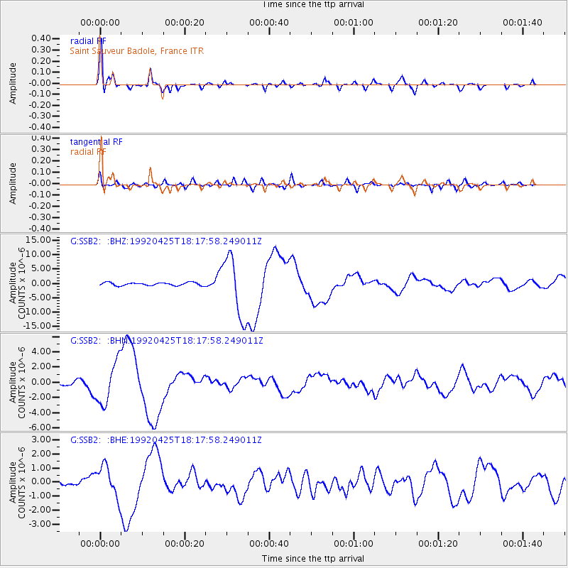
Signal To Noise
| Channel | StoN | STA | LTA |
| G:SSB2: :BHN:19920425T18:17:58.249011Z | 12.953717 | 2.8693166E-6 | 2.2150527E-7 |
| G:SSB2: :BHE:19920425T18:17:58.249011Z | 3.842532 | 1.1710968E-6 | 3.0477213E-7 |
| G:SSB2: :BHZ:19920425T18:17:58.249011Z | 20.758478 | 1.0972775E-5 | 5.2859247E-7 |
| Arrivals |
| Ps | 3.0 SECOND |
| PpPs | 12 SECOND |
| PsPs/PpSs | 15 SECOND |


