You are here: Home > Network List > TA - USArray Transportable Network (new EarthScope stations) Stations List
> Station L40A Anamosa, IA, USA > Earthquake Result Viewer
L40A Anamosa, IA, USA - Earthquake Result Viewer
| Earthquake location: |
Kuril Islands |
| Earthquake latitude/longitude: |
49.4/155.9 |
| Earthquake time(UTC): |
2012/07/20 (202) 06:10:25 GMT |
| Earthquake Depth: |
19 km |
| Earthquake Magnitude: |
5.7 MB, 5.7 MS, 6.0 MW, 6.1 MW |
| Earthquake Catalog/Contributor: |
WHDF/NEIC |
|
| Network: |
TA USArray Transportable Network (new EarthScope stations) |
| Station: |
L40A Anamosa, IA, USA |
| Lat/Lon: |
42.06 N/91.22 W |
| Elevation: |
242 m |
|
| Distance: |
71.6 deg |
| Az: |
46.323 deg |
| Baz: |
320.622 deg |
| Ray Param: |
0.054230206 |
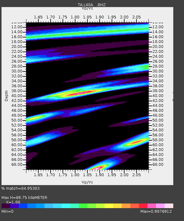
| Estimated Moho Depth: |
69.75 km |
| Estimated Crust Vp/Vs: |
1.88 |
| Assumed Crust Vp: |
6.53 km/s |
| Estimated Crust Vs: |
3.474 km/s |
| Estimated Crust Poisson's Ratio: |
0.30 |
|
| Radial Match: |
84.95383 % |
| Radial Bump: |
400 |
| Transverse Match: |
66.49349 % |
| Transverse Bump: |
400 |
| SOD ConfigId: |
468427 |
| Insert Time: |
2013-02-21 22:59:14.007 +0000 |
| GWidth: |
2.5 |
| Max Bumps: |
400 |
| Tol: |
0.001 |
|

Signal To Noise
| Channel | StoN | STA | LTA |
| TA:L40A: :BHZ:20120720T06:21:13.700029Z | 6.01097 | 5.248586E-7 | 8.7316785E-8 |
| TA:L40A: :BHN:20120720T06:21:13.700029Z | 1.631833 | 1.7114644E-7 | 1.04879874E-7 |
| TA:L40A: :BHE:20120720T06:21:13.700029Z | 1.8309712 | 1.567872E-7 | 8.563062E-8 |
| Arrivals |
| Ps | 9.7 SECOND |
| PpPs | 30 SECOND |
| PsPs/PpSs | 39 SECOND |


