You are here: Home > Network List > G - GEOSCOPE Stations List
> Station SSB2 Saint Sauveur Badole, France > Earthquake Result Viewer
SSB2 Saint Sauveur Badole, France - Earthquake Result Viewer
| Earthquake location: |
East Of Kuril Islands |
| Earthquake latitude/longitude: |
47.6/155.6 |
| Earthquake time(UTC): |
1992/05/28 (149) 21:24:50 GMT |
| Earthquake Depth: |
49 km |
| Earthquake Magnitude: |
6.0 MB, 5.3 MS |
| Earthquake Catalog/Contributor: |
WHDF/NEIC |
|
| Network: |
G GEOSCOPE |
| Station: |
SSB2 Saint Sauveur Badole, France |
| Lat/Lon: |
45.28 N/4.54 E |
| Elevation: |
700 m |
|
| Distance: |
84.1 deg |
| Az: |
339.933 deg |
| Baz: |
19.205 deg |
| Ray Param: |
0.045644023 |
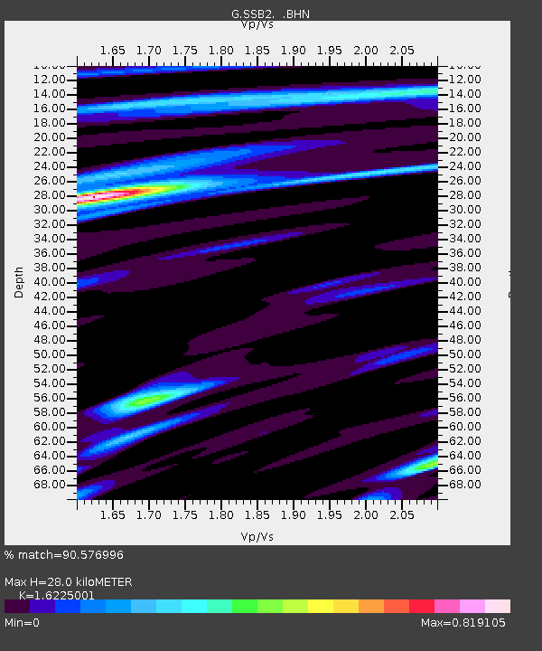
| Estimated Moho Depth: |
28.0 km |
| Estimated Crust Vp/Vs: |
1.62 |
| Assumed Crust Vp: |
6.1 km/s |
| Estimated Crust Vs: |
3.76 km/s |
| Estimated Crust Poisson's Ratio: |
0.19 |
|
| Radial Match: |
90.576996 % |
| Radial Bump: |
400 |
| Transverse Match: |
69.47939 % |
| Transverse Bump: |
400 |
| SOD ConfigId: |
16938 |
| Insert Time: |
2010-02-27 00:22:00.627 +0000 |
| GWidth: |
2.5 |
| Max Bumps: |
400 |
| Tol: |
0.001 |
|

Signal To Noise
| Channel | StoN | STA | LTA |
| G:SSB2: :BHN:19920528T21:36:45.250012Z | 2.7601998 | 1.7662025E-7 | 6.398821E-8 |
| G:SSB2: :BHE:19920528T21:36:45.250012Z | 1.7476727 | 1.0222313E-7 | 5.8491008E-8 |
| G:SSB2: :BHZ:19920528T21:36:45.250012Z | 4.252733 | 3.8367222E-7 | 9.02178E-8 |
| Arrivals |
| Ps | 2.9 SECOND |
| PpPs | 12 SECOND |
| PsPs/PpSs | 15 SECOND |


