You are here: Home > Network List > TA - USArray Transportable Network (new EarthScope stations) Stations List
> Station I41A Arkdale, WI, USA > Earthquake Result Viewer
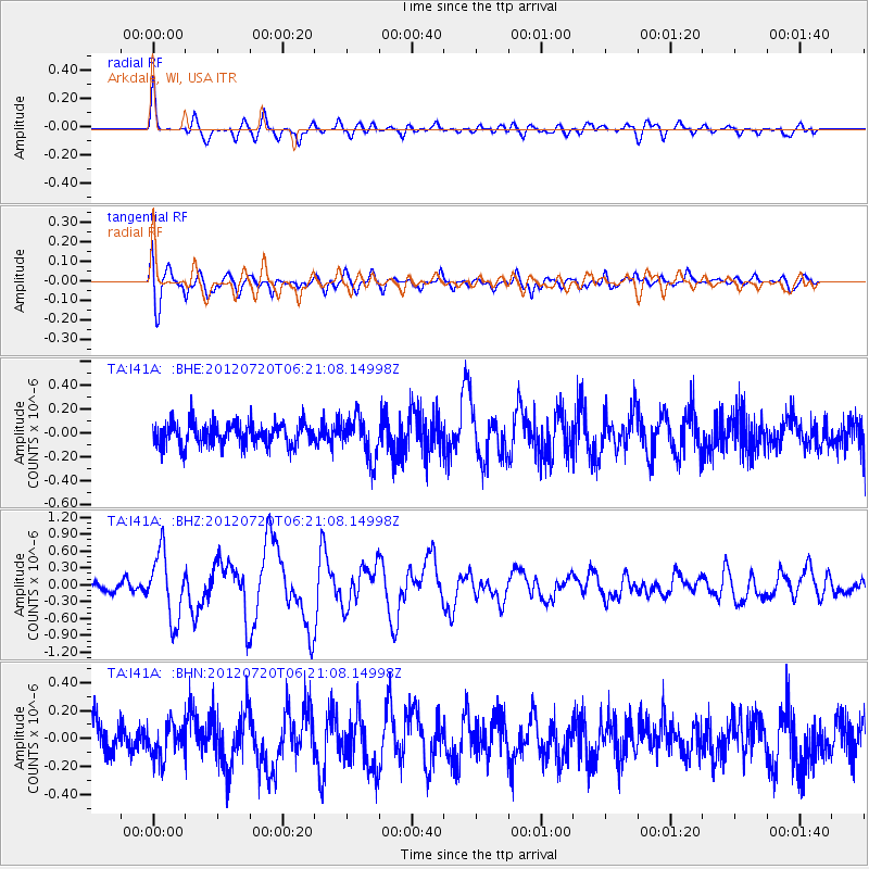
I41A Arkdale, WI, USA - Earthquake Result Viewer
*The percent match for this event was below the threshold and hence no stack was calculated.
| Earthquake location: |
Kuril Islands |
| Earthquake latitude/longitude: |
49.4/155.9 |
| Earthquake time(UTC): |
2012/07/20 (202) 06:10:25 GMT |
| Earthquake Depth: |
19 km |
| Earthquake Magnitude: |
5.7 MB, 5.7 MS, 6.0 MW, 6.1 MW |
| Earthquake Catalog/Contributor: |
WHDF/NEIC |
|
| Network: |
TA USArray Transportable Network (new EarthScope stations) |
| Station: |
I41A Arkdale, WI, USA |
| Lat/Lon: |
44.06 N/89.87 W |
| Elevation: |
289 m |
|
| Distance: |
70.6 deg |
| Az: |
44.177 deg |
| Baz: |
320.847 deg |
| Ray Param: |
$rayparam |
*The percent match for this event was below the threshold and hence was not used in the summary stack. |
|
| Radial Match: |
76.21054 % |
| Radial Bump: |
400 |
| Transverse Match: |
82.229576 % |
| Transverse Bump: |
400 |
| SOD ConfigId: |
468427 |
| Insert Time: |
2013-02-21 23:01:46.652 +0000 |
| GWidth: |
2.5 |
| Max Bumps: |
400 |
| Tol: |
0.001 |
|
Signal To Noise
| Channel | StoN | STA | LTA |
| TA:I41A: :BHZ:20120720T06:21:08.14998Z | 5.5418935 | 5.7798843E-7 | 1.04294394E-7 |
| TA:I41A: :BHN:20120720T06:21:08.14998Z | 0.96864206 | 1.2217251E-7 | 1.261276E-7 |
| TA:I41A: :BHE:20120720T06:21:08.14998Z | 1.7710075 | 1.7254008E-7 | 9.742482E-8 |
| Arrivals |
| Ps | |
| PpPs | |
| PsPs/PpSs | |


