You are here: Home > Network List > G - GEOSCOPE Stations List
> Station SSB2 Saint Sauveur Badole, France > Earthquake Result Viewer
SSB2 Saint Sauveur Badole, France - Earthquake Result Viewer
| Earthquake location: |
Myanmar |
| Earthquake latitude/longitude: |
24.0/95.9 |
| Earthquake time(UTC): |
1992/06/15 (167) 02:48:56 GMT |
| Earthquake Depth: |
16 km |
| Earthquake Magnitude: |
5.7 MB, 6.3 MS |
| Earthquake Catalog/Contributor: |
WHDF/NEIC |
|
| Network: |
G GEOSCOPE |
| Station: |
SSB2 Saint Sauveur Badole, France |
| Lat/Lon: |
45.28 N/4.54 E |
| Elevation: |
700 m |
|
| Distance: |
74.3 deg |
| Az: |
312.837 deg |
| Baz: |
71.795 deg |
| Ray Param: |
0.052433368 |
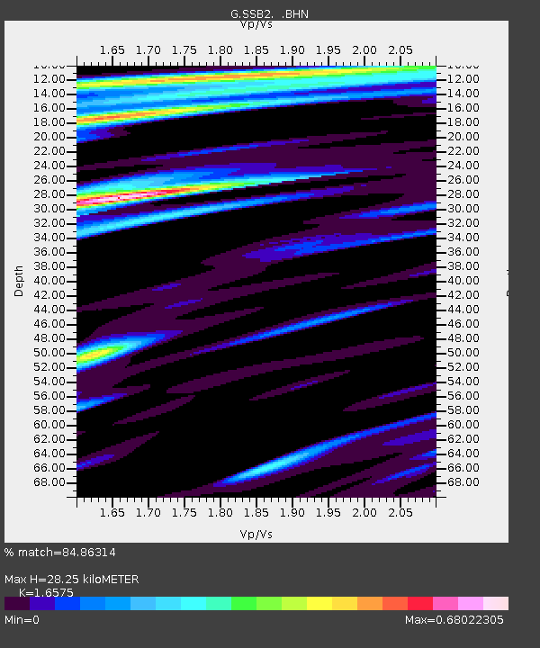
| Estimated Moho Depth: |
28.25 km |
| Estimated Crust Vp/Vs: |
1.66 |
| Assumed Crust Vp: |
6.1 km/s |
| Estimated Crust Vs: |
3.68 km/s |
| Estimated Crust Poisson's Ratio: |
0.21 |
|
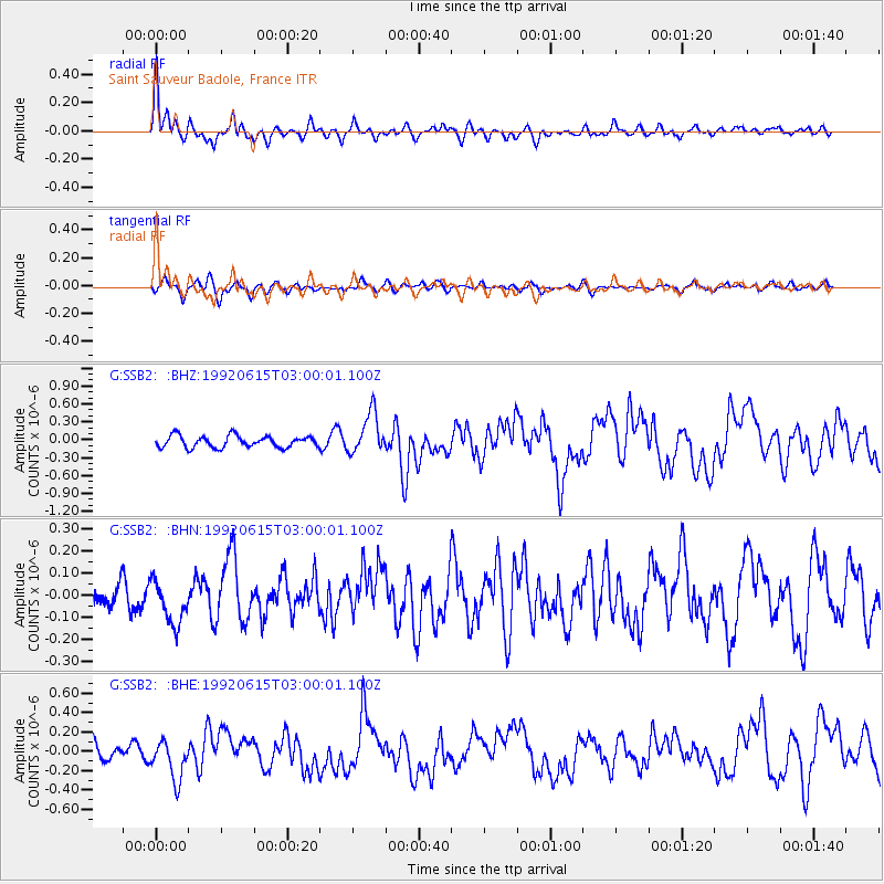
| Radial Match: |
84.86314 % |
| Radial Bump: |
399 |
| Transverse Match: |
58.702152 % |
| Transverse Bump: |
400 |
| SOD ConfigId: |
16938 |
| Insert Time: |
2010-02-27 00:22:04.897 +0000 |
| GWidth: |
2.5 |
| Max Bumps: |
400 |
| Tol: |
0.001 |
|
Signal To Noise
| Channel | StoN | STA | LTA |
| G:SSB2: :BHN:19920615T03:00:01.100Z | 1.2229298 | 1.0263156E-7 | 8.3922686E-8 |
| G:SSB2: :BHE:19920615T03:00:01.100Z | 1.5149165 | 2.0477948E-7 | 1.3517543E-7 |
| G:SSB2: :BHZ:19920615T03:00:01.100Z | 3.5454326 | 3.4256192E-7 | 9.6620624E-8 |
| Arrivals |
| Ps | 3.1 SECOND |
| PpPs | 12 SECOND |
| PsPs/PpSs | 15 SECOND |


