You are here: Home > Network List > TA - USArray Transportable Network (new EarthScope stations) Stations List
> Station E42A Champion, MI, USA > Earthquake Result Viewer
E42A Champion, MI, USA - Earthquake Result Viewer
| Earthquake location: |
Kuril Islands |
| Earthquake latitude/longitude: |
49.4/155.9 |
| Earthquake time(UTC): |
2012/07/20 (202) 06:10:25 GMT |
| Earthquake Depth: |
19 km |
| Earthquake Magnitude: |
5.7 MB, 5.7 MS, 6.0 MW, 6.1 MW |
| Earthquake Catalog/Contributor: |
WHDF/NEIC |
|
| Network: |
TA USArray Transportable Network (new EarthScope stations) |
| Station: |
E42A Champion, MI, USA |
| Lat/Lon: |
46.43 N/87.91 W |
| Elevation: |
475 m |
|
| Distance: |
69.7 deg |
| Az: |
41.451 deg |
| Baz: |
321.306 deg |
| Ray Param: |
0.05547896 |
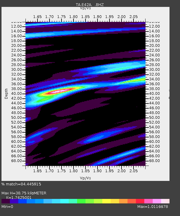
| Estimated Moho Depth: |
38.75 km |
| Estimated Crust Vp/Vs: |
1.74 |
| Assumed Crust Vp: |
6.472 km/s |
| Estimated Crust Vs: |
3.714 km/s |
| Estimated Crust Poisson's Ratio: |
0.25 |
|
| Radial Match: |
84.445915 % |
| Radial Bump: |
333 |
| Transverse Match: |
67.66722 % |
| Transverse Bump: |
400 |
| SOD ConfigId: |
469095 |
| Insert Time: |
2013-02-21 23:12:17.860 +0000 |
| GWidth: |
2.5 |
| Max Bumps: |
400 |
| Tol: |
0.001 |
|

Signal To Noise
| Channel | StoN | STA | LTA |
| TA:E42A: :BHZ:20120720T06:21:02.175005Z | 3.942505 | 7.185839E-7 | 1.8226584E-7 |
| TA:E42A: :BHN:20120720T06:21:02.175005Z | 1.5225407 | 2.4911637E-7 | 1.6361886E-7 |
| TA:E42A: :BHE:20120720T06:21:02.175005Z | 2.1587682 | 2.2428945E-7 | 1.0389696E-7 |
| Arrivals |
| Ps | 4.6 SECOND |
| PpPs | 16 SECOND |
| PsPs/PpSs | 20 SECOND |


