You are here: Home > Network List > TA - USArray Transportable Network (new EarthScope stations) Stations List
> Station P47A Martinsville, IN, USA > Earthquake Result Viewer
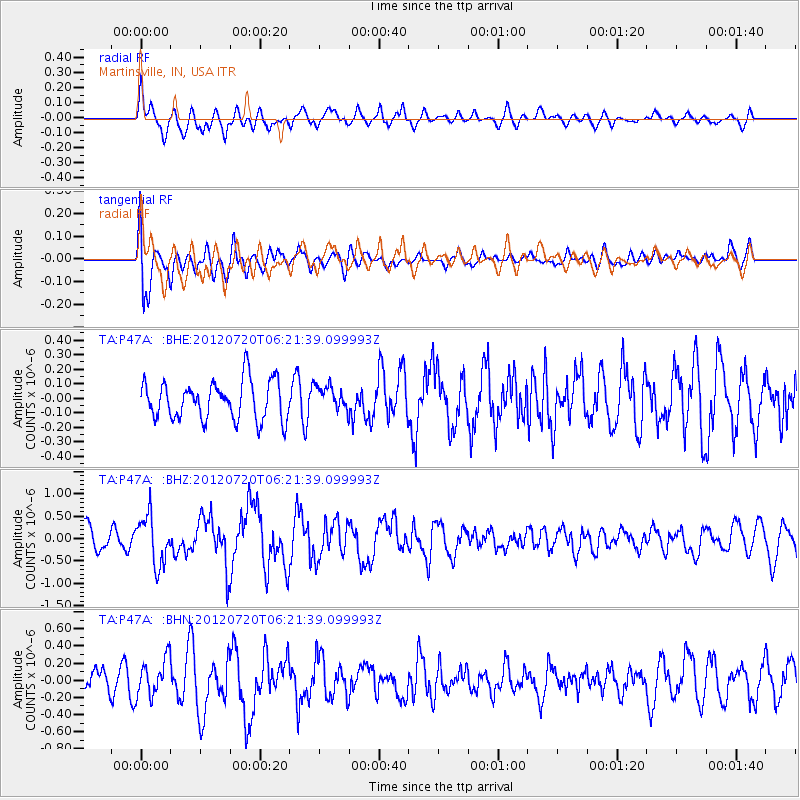
P47A Martinsville, IN, USA - Earthquake Result Viewer
*The percent match for this event was below the threshold and hence no stack was calculated.
| Earthquake location: |
Kuril Islands |
| Earthquake latitude/longitude: |
49.4/155.9 |
| Earthquake time(UTC): |
2012/07/20 (202) 06:10:25 GMT |
| Earthquake Depth: |
19 km |
| Earthquake Magnitude: |
5.7 MB, 5.7 MS, 6.0 MW, 6.1 MW |
| Earthquake Catalog/Contributor: |
WHDF/NEIC |
|
| Network: |
TA USArray Transportable Network (new EarthScope stations) |
| Station: |
P47A Martinsville, IN, USA |
| Lat/Lon: |
39.49 N/86.27 W |
| Elevation: |
246 m |
|
| Distance: |
75.9 deg |
| Az: |
44.883 deg |
| Baz: |
323.443 deg |
| Ray Param: |
$rayparam |
*The percent match for this event was below the threshold and hence was not used in the summary stack. |
|
| Radial Match: |
58.625374 % |
| Radial Bump: |
400 |
| Transverse Match: |
69.26869 % |
| Transverse Bump: |
400 |
| SOD ConfigId: |
469095 |
| Insert Time: |
2013-02-21 23:14:45.547 +0000 |
| GWidth: |
2.5 |
| Max Bumps: |
400 |
| Tol: |
0.001 |
|
Signal To Noise
| Channel | StoN | STA | LTA |
| TA:P47A: :BHZ:20120720T06:21:39.099993Z | 1.8847649 | 5.4397503E-7 | 2.8861692E-7 |
| TA:P47A: :BHN:20120720T06:21:39.099993Z | 1.1605183 | 2.1340263E-7 | 1.8388562E-7 |
| TA:P47A: :BHE:20120720T06:21:39.099993Z | 0.64626056 | 8.566839E-8 | 1.3256013E-7 |
| Arrivals |
| Ps | |
| PpPs | |
| PsPs/PpSs | |


