You are here: Home > Network List > G - GEOSCOPE Stations List
> Station SSB2 Saint Sauveur Badole, France > Earthquake Result Viewer
SSB2 Saint Sauveur Badole, France - Earthquake Result Viewer
| Earthquake location: |
North Of Ascension Island |
| Earthquake latitude/longitude: |
-1.0/-13.6 |
| Earthquake time(UTC): |
1992/08/28 (241) 18:18:45 GMT |
| Earthquake Depth: |
10 km |
| Earthquake Magnitude: |
6.4 MB, 7.0 MS |
| Earthquake Catalog/Contributor: |
WHDF/NEIC |
|
| Network: |
G GEOSCOPE |
| Station: |
SSB2 Saint Sauveur Badole, France |
| Lat/Lon: |
45.28 N/4.54 E |
| Elevation: |
700 m |
|
| Distance: |
48.8 deg |
| Az: |
16.95 deg |
| Baz: |
204.385 deg |
| Ray Param: |
0.06912456 |
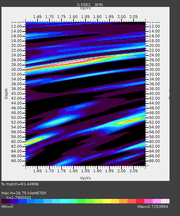
| Estimated Moho Depth: |
26.75 km |
| Estimated Crust Vp/Vs: |
1.79 |
| Assumed Crust Vp: |
6.1 km/s |
| Estimated Crust Vs: |
3.417 km/s |
| Estimated Crust Poisson's Ratio: |
0.27 |
|
| Radial Match: |
93.44996 % |
| Radial Bump: |
256 |
| Transverse Match: |
63.27879 % |
| Transverse Bump: |
400 |
| SOD ConfigId: |
16938 |
| Insert Time: |
2010-02-27 00:22:21.265 +0000 |
| GWidth: |
2.5 |
| Max Bumps: |
400 |
| Tol: |
0.001 |
|

Signal To Noise
| Channel | StoN | STA | LTA |
| G:SSB2: :BHN:19920828T18:26:59.500012Z | 26.012691 | 2.949782E-6 | 1.13397796E-7 |
| G:SSB2: :BHE:19920828T18:26:59.500012Z | 6.506555 | 1.1468637E-6 | 1.7626282E-7 |
| G:SSB2: :BHZ:19920828T18:26:59.500012Z | 28.895617 | 6.1445494E-6 | 2.1264643E-7 |
| Arrivals |
| Ps | 3.6 SECOND |
| PpPs | 12 SECOND |
| PsPs/PpSs | 15 SECOND |


