You are here: Home > Network List > G - GEOSCOPE Stations List
> Station SSB2 Saint Sauveur Badole, France > Earthquake Result Viewer
SSB2 Saint Sauveur Badole, France - Earthquake Result Viewer
| Earthquake location: |
Hokkaido, Japan Region |
| Earthquake latitude/longitude: |
41.1/144.6 |
| Earthquake time(UTC): |
1992/05/07 (128) 06:23:40 GMT |
| Earthquake Depth: |
46 km |
| Earthquake Magnitude: |
5.8 MB, 5.7 MS |
| Earthquake Catalog/Contributor: |
WHDF/NEIC |
|
| Network: |
G GEOSCOPE |
| Station: |
SSB2 Saint Sauveur Badole, France |
| Lat/Lon: |
45.28 N/4.54 E |
| Elevation: |
700 m |
|
| Distance: |
86.9 deg |
| Az: |
333.022 deg |
| Baz: |
29.042 deg |
| Ray Param: |
0.04366879 |
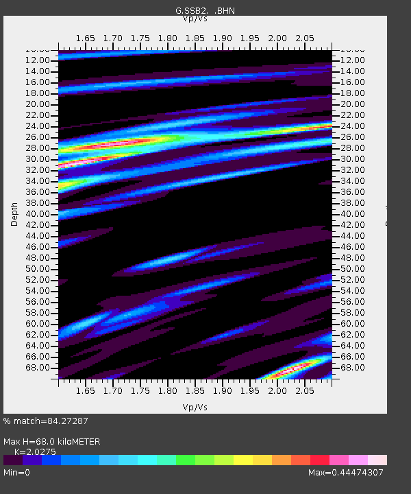
| Estimated Moho Depth: |
68.0 km |
| Estimated Crust Vp/Vs: |
2.03 |
| Assumed Crust Vp: |
6.1 km/s |
| Estimated Crust Vs: |
3.009 km/s |
| Estimated Crust Poisson's Ratio: |
0.34 |
|
| Radial Match: |
84.27287 % |
| Radial Bump: |
400 |
| Transverse Match: |
56.617344 % |
| Transverse Bump: |
400 |
| SOD ConfigId: |
17000 |
| Insert Time: |
2010-02-27 00:22:29.305 +0000 |
| GWidth: |
2.5 |
| Max Bumps: |
400 |
| Tol: |
0.001 |
|
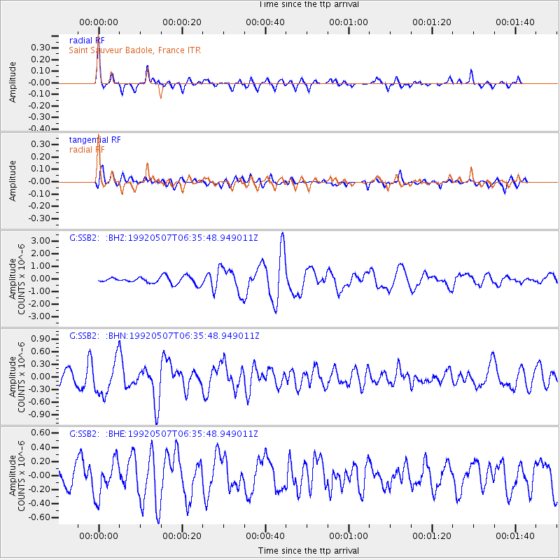
Signal To Noise
| Channel | StoN | STA | LTA |
| G:SSB2: :BHN:19920507T06:35:48.949011Z | 3.0157847 | 4.3781097E-7 | 1.4517315E-7 |
| G:SSB2: :BHE:19920507T06:35:48.949011Z | 1.4400929 | 2.5209525E-7 | 1.7505485E-7 |
| G:SSB2: :BHZ:19920507T06:35:48.949011Z | 3.6968434 | 1.0207153E-6 | 2.7610457E-7 |
| Arrivals |
| Ps | 12 SECOND |
| PpPs | 33 SECOND |
| PsPs/PpSs | 45 SECOND |


