You are here: Home > Network List > TA - USArray Transportable Network (new EarthScope stations) Stations List
> Station Y53A Monroe, GA, USA > Earthquake Result Viewer
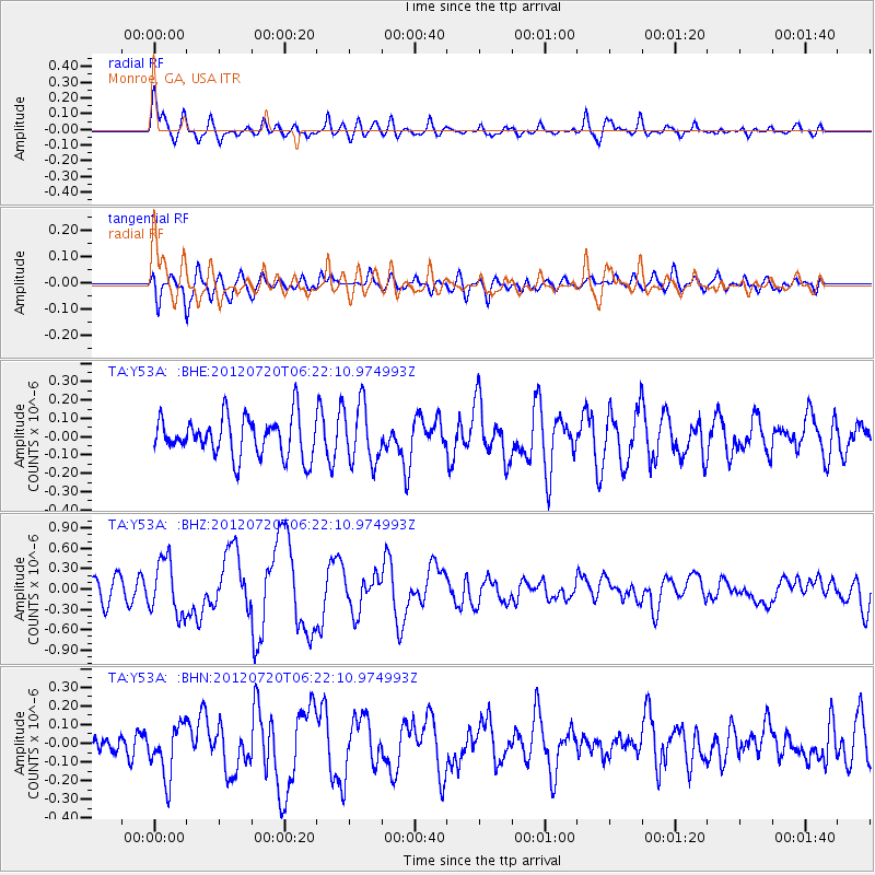
Y53A Monroe, GA, USA - Earthquake Result Viewer
*The percent match for this event was below the threshold and hence no stack was calculated.
| Earthquake location: |
Kuril Islands |
| Earthquake latitude/longitude: |
49.4/155.9 |
| Earthquake time(UTC): |
2012/07/20 (202) 06:10:25 GMT |
| Earthquake Depth: |
19 km |
| Earthquake Magnitude: |
5.7 MB, 5.7 MS, 6.0 MW, 6.1 MW |
| Earthquake Catalog/Contributor: |
WHDF/NEIC |
|
| Network: |
TA USArray Transportable Network (new EarthScope stations) |
| Station: |
Y53A Monroe, GA, USA |
| Lat/Lon: |
33.86 N/83.58 W |
| Elevation: |
234 m |
|
| Distance: |
81.7 deg |
| Az: |
46.427 deg |
| Baz: |
325.342 deg |
| Ray Param: |
$rayparam |
*The percent match for this event was below the threshold and hence was not used in the summary stack. |
|
| Radial Match: |
79.70177 % |
| Radial Bump: |
400 |
| Transverse Match: |
57.126434 % |
| Transverse Bump: |
400 |
| SOD ConfigId: |
469095 |
| Insert Time: |
2013-02-21 23:25:38.396 +0000 |
| GWidth: |
2.5 |
| Max Bumps: |
400 |
| Tol: |
0.001 |
|
Signal To Noise
| Channel | StoN | STA | LTA |
| TA:Y53A: :BHZ:20120720T06:22:10.974993Z | 2.2740445 | 4.0449024E-7 | 1.7787261E-7 |
| TA:Y53A: :BHN:20120720T06:22:10.974993Z | 2.5554695 | 1.4106028E-7 | 5.519936E-8 |
| TA:Y53A: :BHE:20120720T06:22:10.974993Z | 1.4725648 | 1.5868876E-7 | 1.0776351E-7 |
| Arrivals |
| Ps | |
| PpPs | |
| PsPs/PpSs | |


