You are here: Home > Network List > TA - USArray Transportable Network (new EarthScope stations) Stations List
> Station V50A Pikevile, TN, USA > Earthquake Result Viewer
V50A Pikevile, TN, USA - Earthquake Result Viewer
| Earthquake location: |
Kuril Islands |
| Earthquake latitude/longitude: |
49.4/155.9 |
| Earthquake time(UTC): |
2012/07/20 (202) 06:10:25 GMT |
| Earthquake Depth: |
19 km |
| Earthquake Magnitude: |
5.7 MB, 5.7 MS, 6.0 MW, 6.1 MW |
| Earthquake Catalog/Contributor: |
WHDF/NEIC |
|
| Network: |
TA USArray Transportable Network (new EarthScope stations) |
| Station: |
V50A Pikevile, TN, USA |
| Lat/Lon: |
35.67 N/85.10 W |
| Elevation: |
287 m |
|
| Distance: |
79.5 deg |
| Az: |
46.407 deg |
| Baz: |
324.478 deg |
| Ray Param: |
0.0488842 |
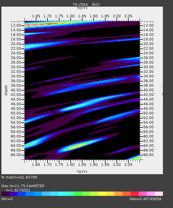
| Estimated Moho Depth: |
11.75 km |
| Estimated Crust Vp/Vs: |
1.62 |
| Assumed Crust Vp: |
6.35 km/s |
| Estimated Crust Vs: |
3.926 km/s |
| Estimated Crust Poisson's Ratio: |
0.19 |
|
| Radial Match: |
81.94799 % |
| Radial Bump: |
342 |
| Transverse Match: |
58.76426 % |
| Transverse Bump: |
388 |
| SOD ConfigId: |
469095 |
| Insert Time: |
2013-02-21 23:26:22.079 +0000 |
| GWidth: |
2.5 |
| Max Bumps: |
400 |
| Tol: |
0.001 |
|
Signal To Noise
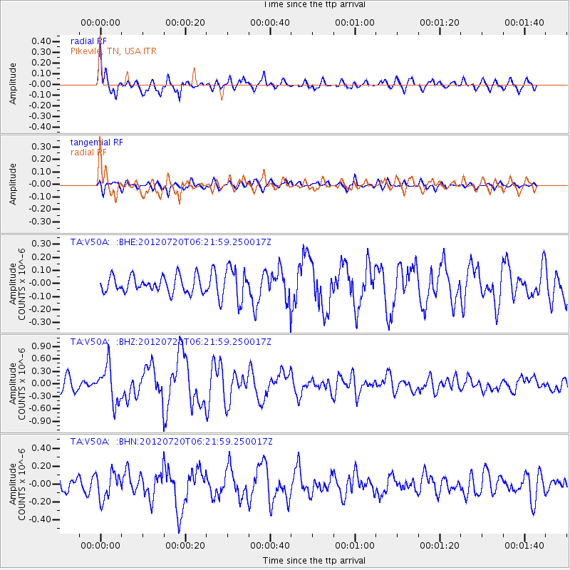
| Channel | StoN | STA | LTA |
| TA:V50A: :BHZ:20120720T06:21:59.250017Z | 2.9030042 | 4.5429692E-7 | 1.5649199E-7 |
| TA:V50A: :BHN:20120720T06:21:59.250017Z | 1.7268904 | 1.468323E-7 | 8.502699E-8 |
| TA:V50A: :BHE:20120720T06:21:59.250017Z | 2.0434647 | 1.2370762E-7 | 6.053818E-8 |
| Arrivals |
| Ps | 1.2 SECOND |
| PpPs | 4.7 SECOND |
| PsPs/PpSs | 5.9 SECOND |


