You are here: Home > Network List > G - GEOSCOPE Stations List
> Station SSB2 Saint Sauveur Badole, France > Earthquake Result Viewer
SSB2 Saint Sauveur Badole, France - Earthquake Result Viewer
| Earthquake location: |
Hokkaido, Japan Region |
| Earthquake latitude/longitude: |
41.4/142.1 |
| Earthquake time(UTC): |
1992/07/12 (194) 11:08:56 GMT |
| Earthquake Depth: |
70 km |
| Earthquake Magnitude: |
5.9 MB |
| Earthquake Catalog/Contributor: |
WHDF/NEIC |
|
| Network: |
G GEOSCOPE |
| Station: |
SSB2 Saint Sauveur Badole, France |
| Lat/Lon: |
45.28 N/4.54 E |
| Elevation: |
700 m |
|
| Distance: |
85.7 deg |
| Az: |
331.427 deg |
| Baz: |
30.616 deg |
| Ray Param: |
0.04446523 |
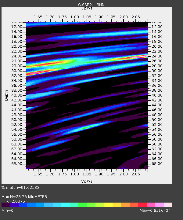
| Estimated Moho Depth: |
23.75 km |
| Estimated Crust Vp/Vs: |
2.09 |
| Assumed Crust Vp: |
6.1 km/s |
| Estimated Crust Vs: |
2.922 km/s |
| Estimated Crust Poisson's Ratio: |
0.35 |
|
| Radial Match: |
91.02133 % |
| Radial Bump: |
400 |
| Transverse Match: |
81.14777 % |
| Transverse Bump: |
400 |
| SOD ConfigId: |
17000 |
| Insert Time: |
2010-02-27 00:22:33.826 +0000 |
| GWidth: |
2.5 |
| Max Bumps: |
400 |
| Tol: |
0.001 |
|
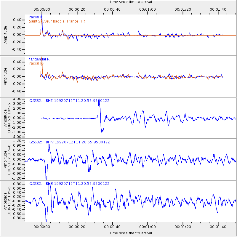
Signal To Noise
| Channel | StoN | STA | LTA |
| G:SSB2: :BHN:19920712T11:20:55.950012Z | 6.082535 | 5.7783836E-7 | 9.49996E-8 |
| G:SSB2: :BHE:19920712T11:20:55.950012Z | 6.488735 | 5.129895E-7 | 7.905847E-8 |
| G:SSB2: :BHZ:19920712T11:20:55.950012Z | 27.35869 | 1.928814E-6 | 7.050096E-8 |
| Arrivals |
| Ps | 4.3 SECOND |
| PpPs | 12 SECOND |
| PsPs/PpSs | 16 SECOND |


