You are here: Home > Network List > IU - Global Seismograph Network (GSN - IRIS/USGS) Stations List
> Station RSSD Black Hills, South Dakota, USA > Earthquake Result Viewer
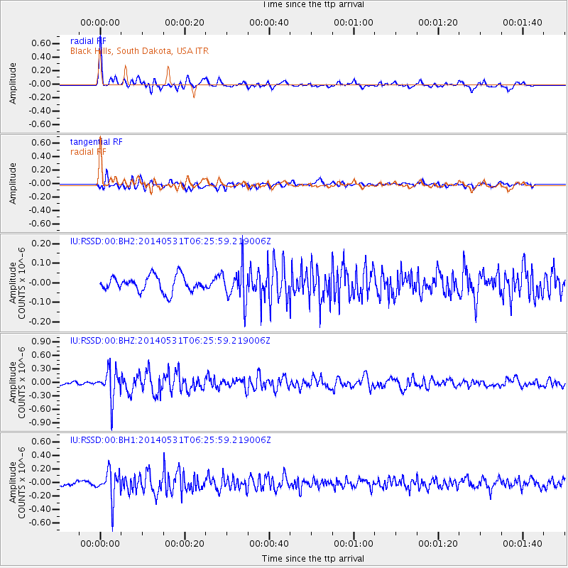
RSSD Black Hills, South Dakota, USA - Earthquake Result Viewer
*The percent match for this event was below the threshold and hence no stack was calculated.
| Earthquake location: |
Komandorskiye Ostrova Region |
| Earthquake latitude/longitude: |
55.0/165.7 |
| Earthquake time(UTC): |
2014/05/31 (151) 06:16:56 GMT |
| Earthquake Depth: |
20 km |
| Earthquake Magnitude: |
5.5 MW |
| Earthquake Catalog/Contributor: |
ISC/ISC |
|
| Network: |
IU Global Seismograph Network (GSN - IRIS/USGS) |
| Station: |
RSSD Black Hills, South Dakota, USA |
| Lat/Lon: |
44.12 N/104.04 W |
| Elevation: |
2090 m |
|
| Distance: |
55.6 deg |
| Az: |
60.795 deg |
| Baz: |
315.7 deg |
| Ray Param: |
$rayparam |
*The percent match for this event was below the threshold and hence was not used in the summary stack. |
|
| Radial Match: |
75.02334 % |
| Radial Bump: |
400 |
| Transverse Match: |
72.84315 % |
| Transverse Bump: |
400 |
| SOD ConfigId: |
3390531 |
| Insert Time: |
2019-04-12 02:46:38.663 +0000 |
| GWidth: |
2.5 |
| Max Bumps: |
400 |
| Tol: |
0.001 |
|
Signal To Noise
| Channel | StoN | STA | LTA |
| IU:RSSD:00:BHZ:20140531T06:25:59.219006Z | 4.6482487 | 3.295377E-7 | 7.089503E-8 |
| IU:RSSD:00:BH1:20140531T06:25:59.219006Z | 4.2425623 | 2.1418228E-7 | 5.0484175E-8 |
| IU:RSSD:00:BH2:20140531T06:25:59.219006Z | 2.1923306 | 8.698815E-8 | 3.967839E-8 |
| Arrivals |
| Ps | |
| PpPs | |
| PsPs/PpSs | |


