You are here: Home > Network List > UW - Pacific Northwest Regional Seismic Network Stations List
> Station MRBL Marblemount, WA, USA > Earthquake Result Viewer
MRBL Marblemount, WA, USA - Earthquake Result Viewer
| Earthquake location: |
Kuril Islands |
| Earthquake latitude/longitude: |
49.4/155.9 |
| Earthquake time(UTC): |
2012/07/20 (202) 06:10:25 GMT |
| Earthquake Depth: |
19 km |
| Earthquake Magnitude: |
5.7 MB, 5.7 MS, 6.0 MW, 6.1 MW |
| Earthquake Catalog/Contributor: |
WHDF/NEIC |
|
| Network: |
UW Pacific Northwest Regional Seismic Network |
| Station: |
MRBL Marblemount, WA, USA |
| Lat/Lon: |
48.52 N/121.48 W |
| Elevation: |
75 m |
|
| Distance: |
51.6 deg |
| Az: |
57.309 deg |
| Baz: |
304.227 deg |
| Ray Param: |
0.06730088 |
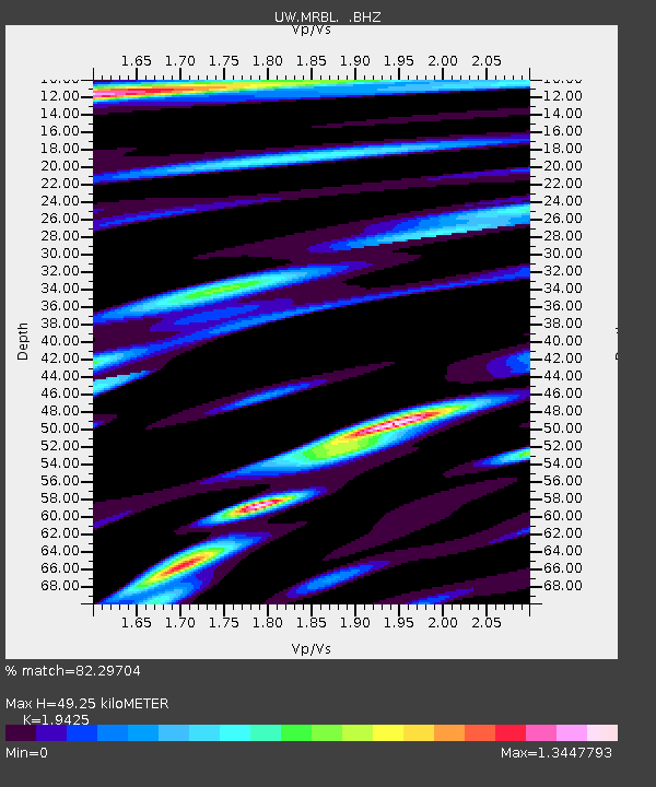
| Estimated Moho Depth: |
49.25 km |
| Estimated Crust Vp/Vs: |
1.94 |
| Assumed Crust Vp: |
6.566 km/s |
| Estimated Crust Vs: |
3.38 km/s |
| Estimated Crust Poisson's Ratio: |
0.32 |
|
| Radial Match: |
82.29704 % |
| Radial Bump: |
400 |
| Transverse Match: |
80.67433 % |
| Transverse Bump: |
400 |
| SOD ConfigId: |
469095 |
| Insert Time: |
2013-02-21 23:30:47.598 +0000 |
| GWidth: |
2.5 |
| Max Bumps: |
400 |
| Tol: |
0.001 |
|
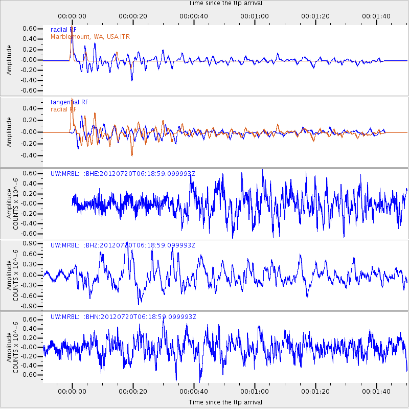
Signal To Noise
| Channel | StoN | STA | LTA |
| UW:MRBL: :BHZ:20120720T06:18:59.099993Z | 2.1620705 | 1.8915088E-7 | 8.7485994E-8 |
| UW:MRBL: :BHN:20120720T06:18:59.099993Z | 1.3072735 | 1.06076136E-7 | 8.1143035E-8 |
| UW:MRBL: :BHE:20120720T06:18:59.099993Z | 1.1273743 | 1.202669E-7 | 1.0667878E-7 |
| Arrivals |
| Ps | 7.5 SECOND |
| PpPs | 21 SECOND |
| PsPs/PpSs | 28 SECOND |


