You are here: Home > Network List > G - GEOSCOPE Stations List
> Station SSB2 Saint Sauveur Badole, France > Earthquake Result Viewer
SSB2 Saint Sauveur Badole, France - Earthquake Result Viewer
| Earthquake location: |
Alaska Peninsula |
| Earthquake latitude/longitude: |
55.0/-160.5 |
| Earthquake time(UTC): |
1993/05/25 (145) 23:16:43 GMT |
| Earthquake Depth: |
33 km |
| Earthquake Magnitude: |
6.2 MB, 5.8 MS, 6.3 ML |
| Earthquake Catalog/Contributor: |
WHDF/NEIC |
|
| Network: |
G GEOSCOPE |
| Station: |
SSB2 Saint Sauveur Badole, France |
| Lat/Lon: |
45.28 N/4.54 E |
| Elevation: |
700 m |
|
| Distance: |
79.3 deg |
| Az: |
10.704 deg |
| Baz: |
351.289 deg |
| Ray Param: |
0.04903934 |
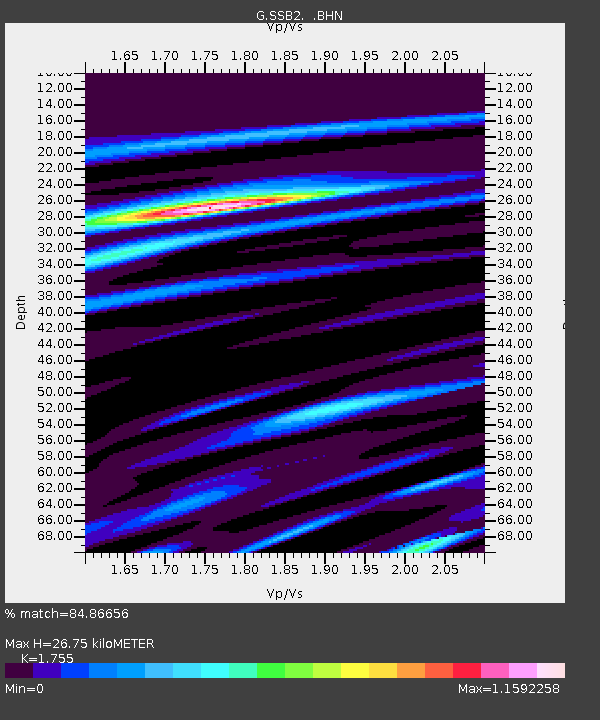
| Estimated Moho Depth: |
26.75 km |
| Estimated Crust Vp/Vs: |
1.75 |
| Assumed Crust Vp: |
6.1 km/s |
| Estimated Crust Vs: |
3.476 km/s |
| Estimated Crust Poisson's Ratio: |
0.26 |
|
| Radial Match: |
84.86656 % |
| Radial Bump: |
400 |
| Transverse Match: |
62.003723 % |
| Transverse Bump: |
400 |
| SOD ConfigId: |
16938 |
| Insert Time: |
2010-02-27 00:22:40.267 +0000 |
| GWidth: |
2.5 |
| Max Bumps: |
400 |
| Tol: |
0.001 |
|

Signal To Noise
| Channel | StoN | STA | LTA |
| G:SSB2: :BHN:19930525T23:28:13.900024Z | 2.31671 | 2.9423668E-7 | 1.2700626E-7 |
| G:SSB2: :BHE:19930525T23:28:13.900024Z | 0.43904278 | 8.009189E-8 | 1.8242388E-7 |
| G:SSB2: :BHZ:19930525T23:28:13.900024Z | 3.6110244 | 6.589184E-7 | 1.824741E-7 |
| Arrivals |
| Ps | 3.4 SECOND |
| PpPs | 12 SECOND |
| PsPs/PpSs | 15 SECOND |


