You are here: Home > Network List > G - GEOSCOPE Stations List
> Station IVI Ivittuut, Greenland > Earthquake Result Viewer
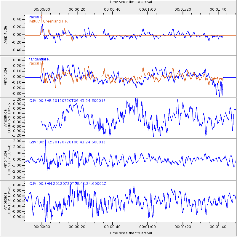
IVI Ivittuut, Greenland - Earthquake Result Viewer
*The percent match for this event was below the threshold and hence no stack was calculated.
| Earthquake location: |
Kuril Islands |
| Earthquake latitude/longitude: |
49.4/156.1 |
| Earthquake time(UTC): |
2012/07/20 (202) 06:32:56 GMT |
| Earthquake Depth: |
10 km |
| Earthquake Magnitude: |
5.8 MB, 5.5 MS, 5.8 MW, 5.9 MW |
| Earthquake Catalog/Contributor: |
WHDF/NEIC |
|
| Network: |
G GEOSCOPE |
| Station: |
IVI Ivittuut, Greenland |
| Lat/Lon: |
61.21 N/48.17 W |
| Elevation: |
15 m |
|
| Distance: |
68.1 deg |
| Az: |
12.404 deg |
| Baz: |
343.135 deg |
| Ray Param: |
$rayparam |
*The percent match for this event was below the threshold and hence was not used in the summary stack. |
|
| Radial Match: |
56.360603 % |
| Radial Bump: |
400 |
| Transverse Match: |
48.0039 % |
| Transverse Bump: |
400 |
| SOD ConfigId: |
469095 |
| Insert Time: |
2013-02-21 23:36:59.552 +0000 |
| GWidth: |
2.5 |
| Max Bumps: |
400 |
| Tol: |
0.001 |
|
Signal To Noise
| Channel | StoN | STA | LTA |
| G:IVI:00:BHZ:20120720T06:43:24.60001Z | 3.2746892 | 1.1009314E-6 | 3.3619418E-7 |
| G:IVI:00:BHN:20120720T06:43:24.60001Z | 0.9444183 | 4.903859E-7 | 5.192465E-7 |
| G:IVI:00:BHE:20120720T06:43:24.60001Z | 1.0123348 | 5.7771916E-7 | 5.706799E-7 |
| Arrivals |
| Ps | |
| PpPs | |
| PsPs/PpSs | |


