You are here: Home > Network List > MN - MEDNET Project Stations List
> Station WDD Wield Dalam, Malta > Earthquake Result Viewer
WDD Wield Dalam, Malta - Earthquake Result Viewer
| Earthquake location: |
Kuril Islands |
| Earthquake latitude/longitude: |
49.4/156.1 |
| Earthquake time(UTC): |
2012/07/20 (202) 06:32:56 GMT |
| Earthquake Depth: |
10 km |
| Earthquake Magnitude: |
5.8 MB, 5.5 MS, 5.8 MW, 5.9 MW |
| Earthquake Catalog/Contributor: |
WHDF/NEIC |
|
| Network: |
MN MEDNET Project |
| Station: |
WDD Wield Dalam, Malta |
| Lat/Lon: |
35.87 N/14.52 E |
| Elevation: |
41 m |
|
| Distance: |
88.6 deg |
| Az: |
329.697 deg |
| Baz: |
23.967 deg |
| Ray Param: |
0.042492017 |
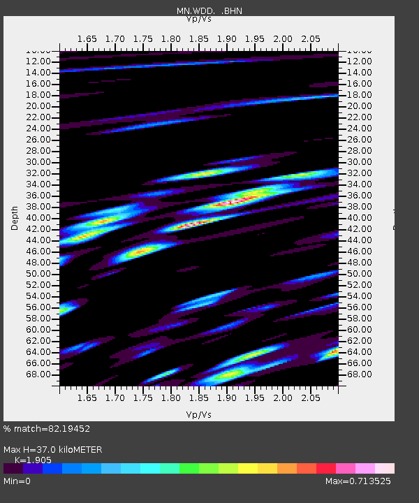
| Estimated Moho Depth: |
37.0 km |
| Estimated Crust Vp/Vs: |
1.90 |
| Assumed Crust Vp: |
4.05 km/s |
| Estimated Crust Vs: |
2.126 km/s |
| Estimated Crust Poisson's Ratio: |
0.31 |
|
| Radial Match: |
82.19452 % |
| Radial Bump: |
400 |
| Transverse Match: |
55.012627 % |
| Transverse Bump: |
400 |
| SOD ConfigId: |
469095 |
| Insert Time: |
2013-02-21 23:40:00.912 +0000 |
| GWidth: |
2.5 |
| Max Bumps: |
400 |
| Tol: |
0.001 |
|
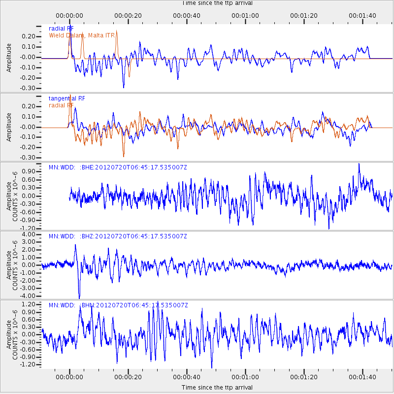
Signal To Noise
| Channel | StoN | STA | LTA |
| MN:WDD: :BHZ:20120720T06:45:17.535007Z | 4.1171184 | 1.4976092E-6 | 3.637518E-7 |
| MN:WDD: :BHN:20120720T06:45:17.535007Z | 2.3866322 | 4.4454177E-7 | 1.8626321E-7 |
| MN:WDD: :BHE:20120720T06:45:17.535007Z | 1.099257 | 1.994102E-7 | 1.8140453E-7 |
| Arrivals |
| Ps | 8.3 SECOND |
| PpPs | 26 SECOND |
| PsPs/PpSs | 35 SECOND |


