You are here: Home > Network List > TA - USArray Transportable Network (new EarthScope stations) Stations List
> Station U43A Rector, AR, USA > Earthquake Result Viewer
U43A Rector, AR, USA - Earthquake Result Viewer
| Earthquake location: |
Kuril Islands |
| Earthquake latitude/longitude: |
49.4/156.1 |
| Earthquake time(UTC): |
2012/07/20 (202) 06:32:56 GMT |
| Earthquake Depth: |
10 km |
| Earthquake Magnitude: |
5.8 MB, 5.5 MS, 5.8 MW, 5.9 MW |
| Earthquake Catalog/Contributor: |
WHDF/NEIC |
|
| Network: |
TA USArray Transportable Network (new EarthScope stations) |
| Station: |
U43A Rector, AR, USA |
| Lat/Lon: |
36.37 N/90.41 W |
| Elevation: |
96 m |
|
| Distance: |
76.3 deg |
| Az: |
49.641 deg |
| Baz: |
321.876 deg |
| Ray Param: |
0.051075958 |
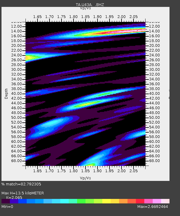
| Estimated Moho Depth: |
13.5 km |
| Estimated Crust Vp/Vs: |
2.07 |
| Assumed Crust Vp: |
6.53 km/s |
| Estimated Crust Vs: |
3.162 km/s |
| Estimated Crust Poisson's Ratio: |
0.35 |
|
| Radial Match: |
82.792305 % |
| Radial Bump: |
400 |
| Transverse Match: |
38.015373 % |
| Transverse Bump: |
400 |
| SOD ConfigId: |
469095 |
| Insert Time: |
2013-02-21 23:54:15.126 +0000 |
| GWidth: |
2.5 |
| Max Bumps: |
400 |
| Tol: |
0.001 |
|

Signal To Noise
| Channel | StoN | STA | LTA |
| TA:U43A: :BHZ:20120720T06:44:13.749973Z | 2.7413142 | 4.5166234E-7 | 1.6476125E-7 |
| TA:U43A: :BHN:20120720T06:44:13.749973Z | 1.1855423 | 3.3236543E-7 | 2.8034884E-7 |
| TA:U43A: :BHE:20120720T06:44:13.749973Z | 1.2983166 | 3.7359447E-7 | 2.87753E-7 |
| Arrivals |
| Ps | 2.3 SECOND |
| PpPs | 6.2 SECOND |
| PsPs/PpSs | 8.4 SECOND |


