You are here: Home > Network List > TA - USArray Transportable Network (new EarthScope stations) Stations List
> Station P46A Rosedale, IN, USA > Earthquake Result Viewer
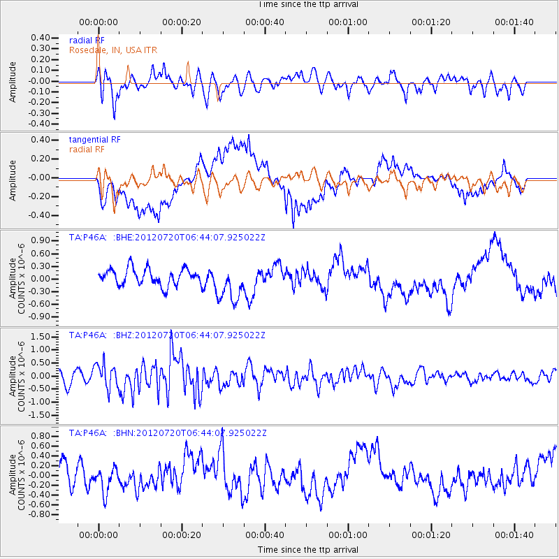
P46A Rosedale, IN, USA - Earthquake Result Viewer
*The percent match for this event was below the threshold and hence no stack was calculated.
| Earthquake location: |
Kuril Islands |
| Earthquake latitude/longitude: |
49.4/156.1 |
| Earthquake time(UTC): |
2012/07/20 (202) 06:32:56 GMT |
| Earthquake Depth: |
10 km |
| Earthquake Magnitude: |
5.8 MB, 5.5 MS, 5.8 MW, 5.9 MW |
| Earthquake Catalog/Contributor: |
WHDF/NEIC |
|
| Network: |
TA USArray Transportable Network (new EarthScope stations) |
| Station: |
P46A Rosedale, IN, USA |
| Lat/Lon: |
39.62 N/87.21 W |
| Elevation: |
194 m |
|
| Distance: |
75.3 deg |
| Az: |
45.534 deg |
| Baz: |
322.831 deg |
| Ray Param: |
$rayparam |
*The percent match for this event was below the threshold and hence was not used in the summary stack. |
|
| Radial Match: |
63.130997 % |
| Radial Bump: |
400 |
| Transverse Match: |
79.19768 % |
| Transverse Bump: |
400 |
| SOD ConfigId: |
469095 |
| Insert Time: |
2013-02-21 23:57:52.000 +0000 |
| GWidth: |
2.5 |
| Max Bumps: |
400 |
| Tol: |
0.001 |
|
Signal To Noise
| Channel | StoN | STA | LTA |
| TA:P46A: :BHZ:20120720T06:44:07.925022Z | 1.809148 | 4.6378713E-7 | 2.5635666E-7 |
| TA:P46A: :BHN:20120720T06:44:07.925022Z | 1.0879478 | 2.7561063E-7 | 2.5333074E-7 |
| TA:P46A: :BHE:20120720T06:44:07.925022Z | 2.3108191 | 4.4328817E-7 | 1.9183162E-7 |
| Arrivals |
| Ps | |
| PpPs | |
| PsPs/PpSs | |


