You are here: Home > Network List > TA - USArray Transportable Network (new EarthScope stations) Stations List
> Station 355A Pearson, GA, USA > Earthquake Result Viewer
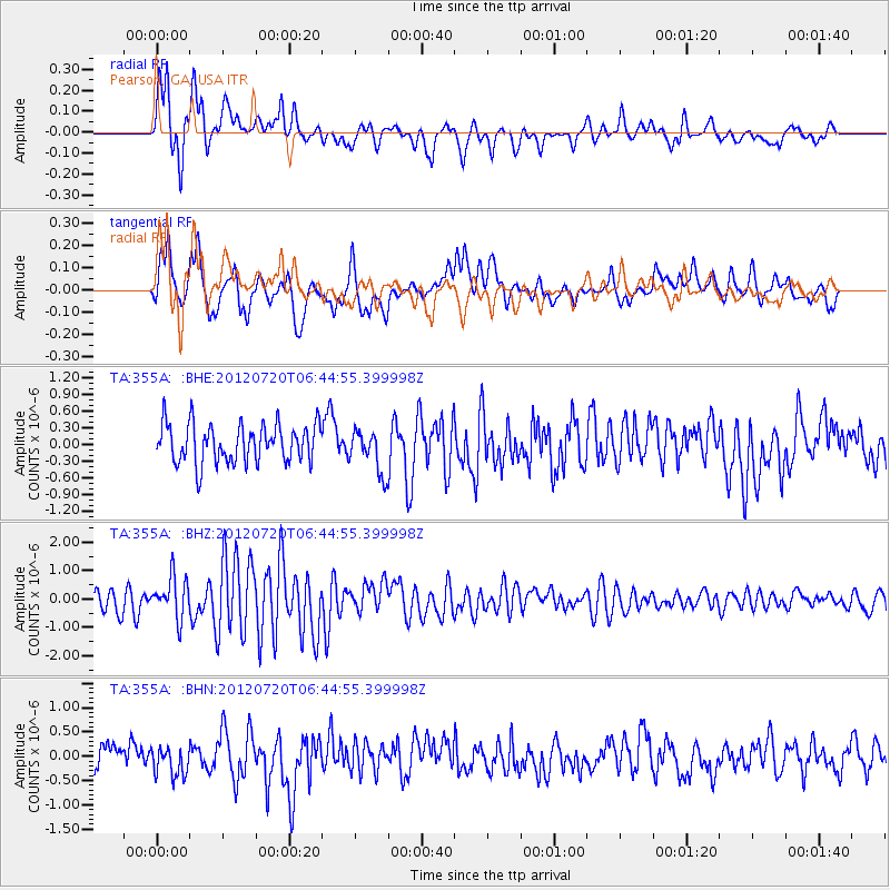
355A Pearson, GA, USA - Earthquake Result Viewer
*The percent match for this event was below the threshold and hence no stack was calculated.
| Earthquake location: |
Kuril Islands |
| Earthquake latitude/longitude: |
49.4/156.1 |
| Earthquake time(UTC): |
2012/07/20 (202) 06:32:56 GMT |
| Earthquake Depth: |
10 km |
| Earthquake Magnitude: |
5.8 MB, 5.5 MS, 5.8 MW, 5.9 MW |
| Earthquake Catalog/Contributor: |
WHDF/NEIC |
|
| Network: |
TA USArray Transportable Network (new EarthScope stations) |
| Station: |
355A Pearson, GA, USA |
| Lat/Lon: |
31.34 N/82.85 W |
| Elevation: |
69 m |
|
| Distance: |
84.1 deg |
| Az: |
47.495 deg |
| Baz: |
325.707 deg |
| Ray Param: |
$rayparam |
*The percent match for this event was below the threshold and hence was not used in the summary stack. |
|
| Radial Match: |
67.56301 % |
| Radial Bump: |
400 |
| Transverse Match: |
57.247364 % |
| Transverse Bump: |
400 |
| SOD ConfigId: |
469095 |
| Insert Time: |
2013-02-22 00:02:36.475 +0000 |
| GWidth: |
2.5 |
| Max Bumps: |
400 |
| Tol: |
0.001 |
|
Signal To Noise
| Channel | StoN | STA | LTA |
| TA:355A: :BHZ:20120720T06:44:55.399998Z | 2.1168046 | 7.1945266E-7 | 3.3987672E-7 |
| TA:355A: :BHN:20120720T06:44:55.399998Z | 1.3472457 | 3.0936621E-7 | 2.2962865E-7 |
| TA:355A: :BHE:20120720T06:44:55.399998Z | 1.1527011 | 3.962876E-7 | 3.4379042E-7 |
| Arrivals |
| Ps | |
| PpPs | |
| PsPs/PpSs | |


