You are here: Home > Network List > TA - USArray Transportable Network (new EarthScope stations) Stations List
> Station S49A Springfield, KY, USA > Earthquake Result Viewer
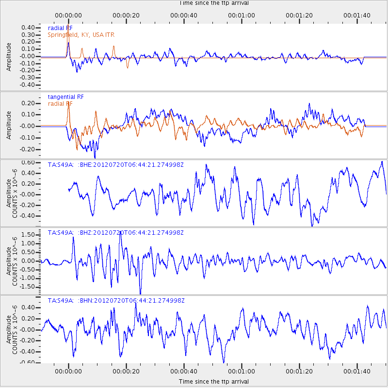
S49A Springfield, KY, USA - Earthquake Result Viewer
*The percent match for this event was below the threshold and hence no stack was calculated.
| Earthquake location: |
Kuril Islands |
| Earthquake latitude/longitude: |
49.4/156.1 |
| Earthquake time(UTC): |
2012/07/20 (202) 06:32:56 GMT |
| Earthquake Depth: |
10 km |
| Earthquake Magnitude: |
5.8 MB, 5.5 MS, 5.8 MW, 5.9 MW |
| Earthquake Catalog/Contributor: |
WHDF/NEIC |
|
| Network: |
TA USArray Transportable Network (new EarthScope stations) |
| Station: |
S49A Springfield, KY, USA |
| Lat/Lon: |
37.78 N/85.29 W |
| Elevation: |
230 m |
|
| Distance: |
77.7 deg |
| Az: |
45.416 deg |
| Baz: |
323.999 deg |
| Ray Param: |
$rayparam |
*The percent match for this event was below the threshold and hence was not used in the summary stack. |
|
| Radial Match: |
67.45708 % |
| Radial Bump: |
400 |
| Transverse Match: |
48.091045 % |
| Transverse Bump: |
400 |
| SOD ConfigId: |
469095 |
| Insert Time: |
2013-02-22 00:05:58.656 +0000 |
| GWidth: |
2.5 |
| Max Bumps: |
400 |
| Tol: |
0.001 |
|
Signal To Noise
| Channel | StoN | STA | LTA |
| TA:S49A: :BHZ:20120720T06:44:21.274998Z | 2.815567 | 5.015265E-7 | 1.7812627E-7 |
| TA:S49A: :BHN:20120720T06:44:21.274998Z | 1.421837 | 2.2499776E-7 | 1.5824442E-7 |
| TA:S49A: :BHE:20120720T06:44:21.274998Z | 1.0571315 | 1.6932744E-7 | 1.6017631E-7 |
| Arrivals |
| Ps | |
| PpPs | |
| PsPs/PpSs | |


