You are here: Home > Network List > TA - USArray Transportable Network (new EarthScope stations) Stations List
> Station G59A Clarenceville, QC, USA > Earthquake Result Viewer
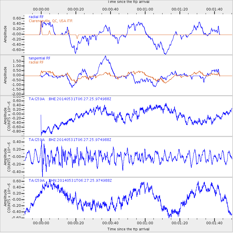
G59A Clarenceville, QC, USA - Earthquake Result Viewer
*The percent match for this event was below the threshold and hence no stack was calculated.
| Earthquake location: |
Komandorskiye Ostrova Region |
| Earthquake latitude/longitude: |
55.0/165.7 |
| Earthquake time(UTC): |
2014/05/31 (151) 06:16:56 GMT |
| Earthquake Depth: |
20 km |
| Earthquake Magnitude: |
5.5 MW |
| Earthquake Catalog/Contributor: |
ISC/ISC |
|
| Network: |
TA USArray Transportable Network (new EarthScope stations) |
| Station: |
G59A Clarenceville, QC, USA |
| Lat/Lon: |
45.08 N/73.18 W |
| Elevation: |
36 m |
|
| Distance: |
68.5 deg |
| Az: |
40.664 deg |
| Baz: |
327.995 deg |
| Ray Param: |
$rayparam |
*The percent match for this event was below the threshold and hence was not used in the summary stack. |
|
| Radial Match: |
15.043439 % |
| Radial Bump: |
400 |
| Transverse Match: |
14.150824 % |
| Transverse Bump: |
400 |
| SOD ConfigId: |
3390531 |
| Insert Time: |
2019-04-12 02:50:58.075 +0000 |
| GWidth: |
2.5 |
| Max Bumps: |
400 |
| Tol: |
0.001 |
|
Signal To Noise
| Channel | StoN | STA | LTA |
| TA:G59A: :BHZ:20140531T06:27:25.974988Z | 2.9727185 | 2.2083212E-7 | 7.4286255E-8 |
| TA:G59A: :BHN:20140531T06:27:25.974988Z | 3.8809998 | 7.4869837E-7 | 1.9291379E-7 |
| TA:G59A: :BHE:20140531T06:27:25.974988Z | 2.4142506 | 6.459815E-7 | 2.675702E-7 |
| Arrivals |
| Ps | |
| PpPs | |
| PsPs/PpSs | |


