You are here: Home > Network List > TA - USArray Transportable Network (new EarthScope stations) Stations List
> Station J04D Umpqua National Forest, Toketee, OR, USA > Earthquake Result Viewer
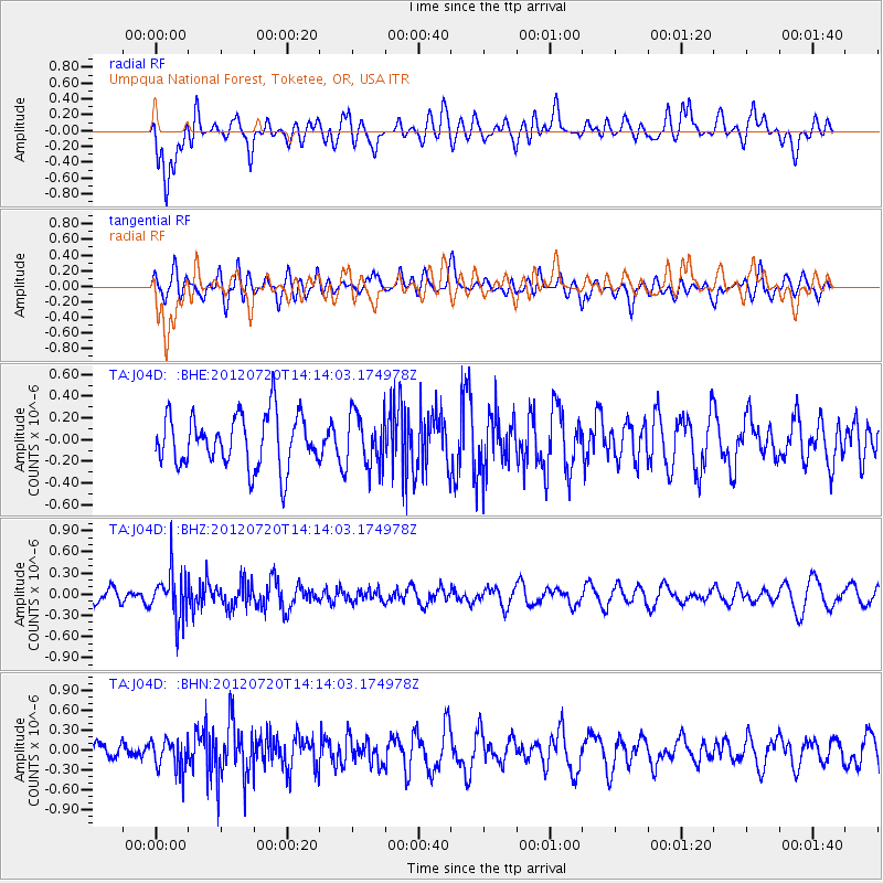
J04D Umpqua National Forest, Toketee, OR, USA - Earthquake Result Viewer
*The percent match for this event was below the threshold and hence no stack was calculated.
| Earthquake location: |
Fiji Islands Region |
| Earthquake latitude/longitude: |
-21.2/-179.3 |
| Earthquake time(UTC): |
2012/07/20 (202) 14:03:13 GMT |
| Earthquake Depth: |
625 km |
| Earthquake Magnitude: |
5.6 MB, 5.6 MW, 5.5 MW |
| Earthquake Catalog/Contributor: |
WHDF/NEIC |
|
| Network: |
TA USArray Transportable Network (new EarthScope stations) |
| Station: |
J04D Umpqua National Forest, Toketee, OR, USA |
| Lat/Lon: |
43.24 N/122.11 W |
| Elevation: |
1948 m |
|
| Distance: |
82.9 deg |
| Az: |
38.235 deg |
| Baz: |
232.199 deg |
| Ray Param: |
$rayparam |
*The percent match for this event was below the threshold and hence was not used in the summary stack. |
|
| Radial Match: |
58.0467 % |
| Radial Bump: |
400 |
| Transverse Match: |
54.596622 % |
| Transverse Bump: |
400 |
| SOD ConfigId: |
469095 |
| Insert Time: |
2013-02-22 00:15:46.587 +0000 |
| GWidth: |
2.5 |
| Max Bumps: |
400 |
| Tol: |
0.001 |
|
Signal To Noise
| Channel | StoN | STA | LTA |
| TA:J04D: :BHZ:20120720T14:14:03.174978Z | 3.6022644 | 3.374609E-7 | 9.3680214E-8 |
| TA:J04D: :BHN:20120720T14:14:03.174978Z | 1.5853822 | 2.3149966E-7 | 1.4602136E-7 |
| TA:J04D: :BHE:20120720T14:14:03.174978Z | 1.0159991 | 2.4353466E-7 | 2.396997E-7 |
| Arrivals |
| Ps | |
| PpPs | |
| PsPs/PpSs | |


