You are here: Home > Network List > TA - USArray Transportable Network (new EarthScope stations) Stations List
> Station O03D Paynes Creek, CA, USA > Earthquake Result Viewer
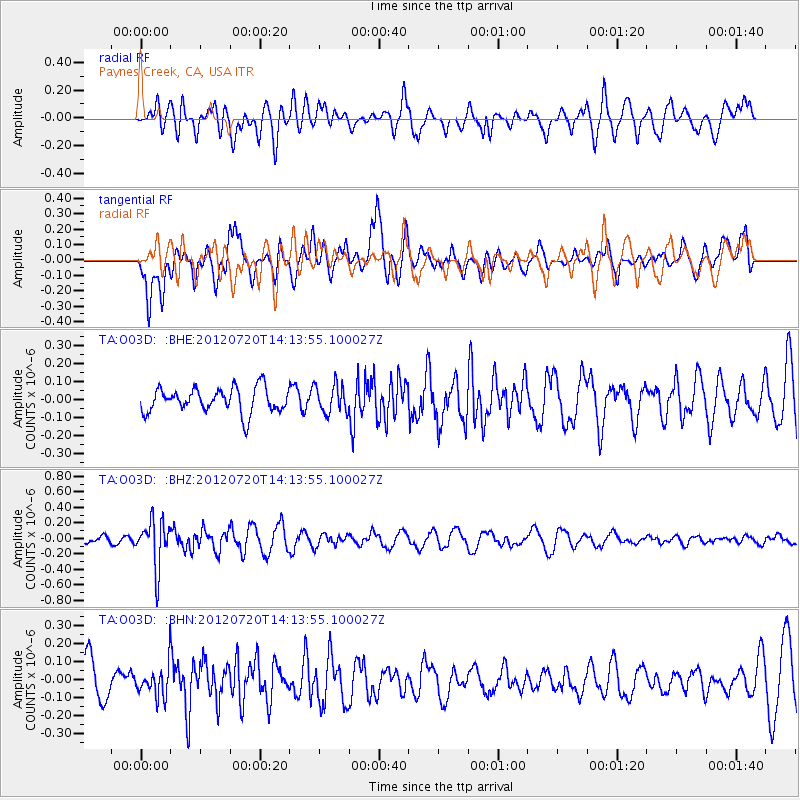
O03D Paynes Creek, CA, USA - Earthquake Result Viewer
*The percent match for this event was below the threshold and hence no stack was calculated.
| Earthquake location: |
Fiji Islands Region |
| Earthquake latitude/longitude: |
-21.2/-179.3 |
| Earthquake time(UTC): |
2012/07/20 (202) 14:03:13 GMT |
| Earthquake Depth: |
625 km |
| Earthquake Magnitude: |
5.6 MB, 5.6 MW, 5.5 MW |
| Earthquake Catalog/Contributor: |
WHDF/NEIC |
|
| Network: |
TA USArray Transportable Network (new EarthScope stations) |
| Station: |
O03D Paynes Creek, CA, USA |
| Lat/Lon: |
40.29 N/121.80 W |
| Elevation: |
968 m |
|
| Distance: |
81.3 deg |
| Az: |
40.733 deg |
| Baz: |
232.747 deg |
| Ray Param: |
$rayparam |
*The percent match for this event was below the threshold and hence was not used in the summary stack. |
|
| Radial Match: |
73.690056 % |
| Radial Bump: |
400 |
| Transverse Match: |
73.15281 % |
| Transverse Bump: |
400 |
| SOD ConfigId: |
469095 |
| Insert Time: |
2013-02-22 00:16:04.414 +0000 |
| GWidth: |
2.5 |
| Max Bumps: |
400 |
| Tol: |
0.001 |
|
Signal To Noise
| Channel | StoN | STA | LTA |
| TA:O03D: :BHZ:20120720T14:13:55.100027Z | 3.7650216 | 3.0324702E-7 | 8.054324E-8 |
| TA:O03D: :BHN:20120720T14:13:55.100027Z | 0.89517736 | 8.317898E-8 | 9.2918995E-8 |
| TA:O03D: :BHE:20120720T14:13:55.100027Z | 1.1354206 | 7.7601996E-8 | 6.834647E-8 |
| Arrivals |
| Ps | |
| PpPs | |
| PsPs/PpSs | |


