You are here: Home > Network List > TA - USArray Transportable Network (new EarthScope stations) Stations List
> Station J46A Howard City, MI, USA > Earthquake Result Viewer
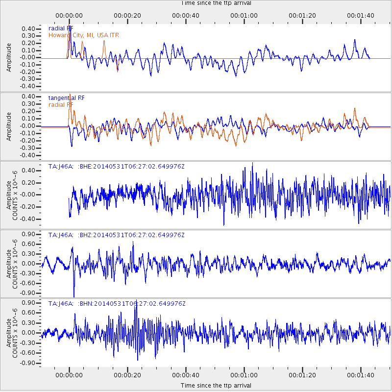
J46A Howard City, MI, USA - Earthquake Result Viewer
*The percent match for this event was below the threshold and hence no stack was calculated.
| Earthquake location: |
Komandorskiye Ostrova Region |
| Earthquake latitude/longitude: |
55.0/165.7 |
| Earthquake time(UTC): |
2014/05/31 (151) 06:16:56 GMT |
| Earthquake Depth: |
20 km |
| Earthquake Magnitude: |
5.5 MW |
| Earthquake Catalog/Contributor: |
ISC/ISC |
|
| Network: |
TA USArray Transportable Network (new EarthScope stations) |
| Station: |
J46A Howard City, MI, USA |
| Lat/Lon: |
43.35 N/85.65 W |
| Elevation: |
275 m |
|
| Distance: |
64.9 deg |
| Az: |
49.758 deg |
| Baz: |
322.916 deg |
| Ray Param: |
$rayparam |
*The percent match for this event was below the threshold and hence was not used in the summary stack. |
|
| Radial Match: |
58.144558 % |
| Radial Bump: |
400 |
| Transverse Match: |
55.415684 % |
| Transverse Bump: |
400 |
| SOD ConfigId: |
3390531 |
| Insert Time: |
2019-04-12 02:51:21.685 +0000 |
| GWidth: |
2.5 |
| Max Bumps: |
400 |
| Tol: |
0.001 |
|
Signal To Noise
| Channel | StoN | STA | LTA |
| TA:J46A: :BHZ:20140531T06:27:02.649976Z | 2.6883607 | 2.8999537E-7 | 1.07870704E-7 |
| TA:J46A: :BHN:20140531T06:27:02.649976Z | 1.7949497 | 1.7598342E-7 | 9.804365E-8 |
| TA:J46A: :BHE:20140531T06:27:02.649976Z | 1.2308625 | 1.3324329E-7 | 1.08251974E-7 |
| Arrivals |
| Ps | |
| PpPs | |
| PsPs/PpSs | |


