You are here: Home > Network List > UW - Pacific Northwest Regional Seismic Network Stations List
> Station UMAT Pilot Rock, OR, USA > Earthquake Result Viewer
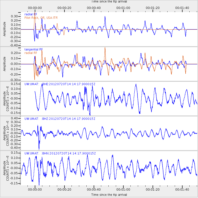
UMAT Pilot Rock, OR, USA - Earthquake Result Viewer
*The percent match for this event was below the threshold and hence no stack was calculated.
| Earthquake location: |
Fiji Islands Region |
| Earthquake latitude/longitude: |
-21.2/-179.3 |
| Earthquake time(UTC): |
2012/07/20 (202) 14:03:13 GMT |
| Earthquake Depth: |
625 km |
| Earthquake Magnitude: |
5.6 MB, 5.6 MW, 5.5 MW |
| Earthquake Catalog/Contributor: |
WHDF/NEIC |
|
| Network: |
UW Pacific Northwest Regional Seismic Network |
| Station: |
UMAT Pilot Rock, OR, USA |
| Lat/Lon: |
45.29 N/118.96 W |
| Elevation: |
1318 m |
|
| Distance: |
85.9 deg |
| Az: |
37.944 deg |
| Baz: |
234.362 deg |
| Ray Param: |
$rayparam |
*The percent match for this event was below the threshold and hence was not used in the summary stack. |
|
| Radial Match: |
48.298973 % |
| Radial Bump: |
400 |
| Transverse Match: |
50.457638 % |
| Transverse Bump: |
386 |
| SOD ConfigId: |
469095 |
| Insert Time: |
2013-02-22 00:17:01.333 +0000 |
| GWidth: |
2.5 |
| Max Bumps: |
400 |
| Tol: |
0.001 |
|
Signal To Noise
| Channel | StoN | STA | LTA |
| UW:UMAT: :BHZ:20120720T14:14:17.900015Z | 2.4812067 | 1.4497758E-7 | 5.8430274E-8 |
| UW:UMAT: :BHN:20120720T14:14:17.900015Z | 1.2765806 | 8.033917E-8 | 6.29331E-8 |
| UW:UMAT: :BHE:20120720T14:14:17.900015Z | 0.9898388 | 6.093718E-8 | 6.156274E-8 |
| Arrivals |
| Ps | |
| PpPs | |
| PsPs/PpSs | |


