You are here: Home > Network List > TA - USArray Transportable Network (new EarthScope stations) Stations List
> Station J62A Henniker, NH, USA > Earthquake Result Viewer
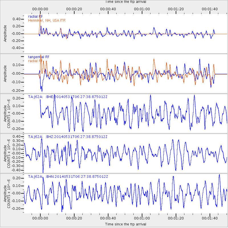
J62A Henniker, NH, USA - Earthquake Result Viewer
*The percent match for this event was below the threshold and hence no stack was calculated.
| Earthquake location: |
Komandorskiye Ostrova Region |
| Earthquake latitude/longitude: |
55.0/165.7 |
| Earthquake time(UTC): |
2014/05/31 (151) 06:16:56 GMT |
| Earthquake Depth: |
20 km |
| Earthquake Magnitude: |
5.5 MW |
| Earthquake Catalog/Contributor: |
ISC/ISC |
|
| Network: |
TA USArray Transportable Network (new EarthScope stations) |
| Station: |
J62A Henniker, NH, USA |
| Lat/Lon: |
43.23 N/71.81 W |
| Elevation: |
266 m |
|
| Distance: |
70.6 deg |
| Az: |
40.801 deg |
| Baz: |
328.992 deg |
| Ray Param: |
$rayparam |
*The percent match for this event was below the threshold and hence was not used in the summary stack. |
|
| Radial Match: |
57.25582 % |
| Radial Bump: |
400 |
| Transverse Match: |
50.32394 % |
| Transverse Bump: |
400 |
| SOD ConfigId: |
3390531 |
| Insert Time: |
2019-04-12 02:51:27.022 +0000 |
| GWidth: |
2.5 |
| Max Bumps: |
400 |
| Tol: |
0.001 |
|
Signal To Noise
| Channel | StoN | STA | LTA |
| TA:J62A: :BHZ:20140531T06:27:38.875012Z | 1.7241099 | 1.8998625E-7 | 1.1019382E-7 |
| TA:J62A: :BHN:20140531T06:27:38.875012Z | 1.5417676 | 1.13393604E-7 | 7.3547795E-8 |
| TA:J62A: :BHE:20140531T06:27:38.875012Z | 1.0859991 | 1.1266765E-7 | 1.0374563E-7 |
| Arrivals |
| Ps | |
| PpPs | |
| PsPs/PpSs | |


