You are here: Home > Network List > CI - Caltech Regional Seismic Network Stations List
> Station FUR Furnace Creek, CA, USA > Earthquake Result Viewer
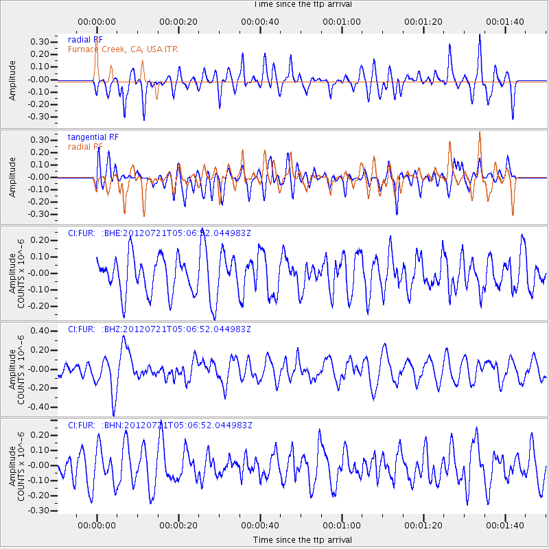
FUR Furnace Creek, CA, USA - Earthquake Result Viewer
*The percent match for this event was below the threshold and hence no stack was calculated.
| Earthquake location: |
East Of North Island, N.Z. |
| Earthquake latitude/longitude: |
-37.7/-180.0 |
| Earthquake time(UTC): |
2012/07/21 (203) 04:54:05 GMT |
| Earthquake Depth: |
12 km |
| Earthquake Magnitude: |
5.7 MB, 5.5 MS, 5.6 MW, 5.7 MW |
| Earthquake Catalog/Contributor: |
WHDF/NEIC |
|
| Network: |
CI Caltech Regional Seismic Network |
| Station: |
FUR Furnace Creek, CA, USA |
| Lat/Lon: |
36.47 N/116.86 W |
| Elevation: |
-37.0 m |
|
| Distance: |
94.1 deg |
| Az: |
46.116 deg |
| Baz: |
225.161 deg |
| Ray Param: |
$rayparam |
*The percent match for this event was below the threshold and hence was not used in the summary stack. |
|
| Radial Match: |
56.82389 % |
| Radial Bump: |
400 |
| Transverse Match: |
54.235725 % |
| Transverse Bump: |
400 |
| SOD ConfigId: |
469095 |
| Insert Time: |
2013-02-22 00:20:56.425 +0000 |
| GWidth: |
2.5 |
| Max Bumps: |
400 |
| Tol: |
0.001 |
|
Signal To Noise
| Channel | StoN | STA | LTA |
| CI:FUR: :BHZ:20120721T05:06:52.044983Z | 3.213012 | 2.0282543E-7 | 6.312626E-8 |
| CI:FUR: :BHN:20120721T05:06:52.044983Z | 1.0868062 | 1.1383817E-7 | 1.0474561E-7 |
| CI:FUR: :BHE:20120721T05:06:52.044983Z | 1.0949851 | 1.1715285E-7 | 1.06990356E-7 |
| Arrivals |
| Ps | |
| PpPs | |
| PsPs/PpSs | |


