You are here: Home > Network List > G - GEOSCOPE Stations List
> Station TAM Tamanrasset, Algeria > Earthquake Result Viewer
TAM Tamanrasset, Algeria - Earthquake Result Viewer
| Earthquake location: |
Sichuan, China |
| Earthquake latitude/longitude: |
31.0/103.3 |
| Earthquake time(UTC): |
2008/05/12 (133) 06:28:01 GMT |
| Earthquake Depth: |
19 km |
| Earthquake Magnitude: |
6.9 MB, 8.1 MS, 7.9 MW, 7.9 MW |
| Earthquake Catalog/Contributor: |
WHDF/NEIC |
|
| Network: |
G GEOSCOPE |
| Station: |
TAM Tamanrasset, Algeria |
| Lat/Lon: |
22.79 N/5.53 E |
| Elevation: |
1377 m |
|
| Distance: |
84.8 deg |
| Az: |
293.359 deg |
| Baz: |
58.671 deg |
| Ray Param: |
0.045178037 |
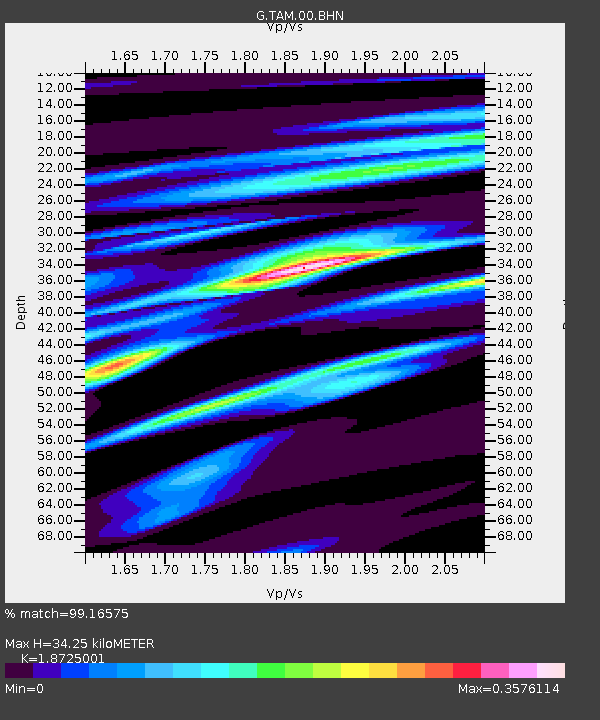
| Estimated Moho Depth: |
34.25 km |
| Estimated Crust Vp/Vs: |
1.87 |
| Assumed Crust Vp: |
6.61 km/s |
| Estimated Crust Vs: |
3.53 km/s |
| Estimated Crust Poisson's Ratio: |
0.30 |
|
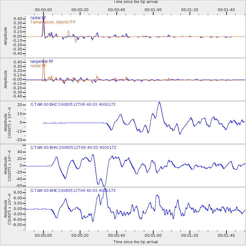
| Radial Match: |
99.16575 % |
| Radial Bump: |
178 |
| Transverse Match: |
93.67249 % |
| Transverse Bump: |
400 |
| SOD ConfigId: |
2504 |
| Insert Time: |
2010-02-27 00:23:22.459 +0000 |
| GWidth: |
2.5 |
| Max Bumps: |
400 |
| Tol: |
0.001 |
|
Signal To Noise
| Channel | StoN | STA | LTA |
| G:TAM:00:BHN:20080512T06:40:03.400017Z | 5.7819276 | 1.1034433E-6 | 1.9084351E-7 |
| G:TAM:00:BHE:20080512T06:40:03.400017Z | 3.3458836 | 1.9121195E-7 | 5.7148416E-8 |
| G:TAM:00:BHZ:20080512T06:40:03.400017Z | 3.337211 | 2.577456E-7 | 7.7233835E-8 |
| Arrivals |
| Ps | 4.6 SECOND |
| PpPs | 15 SECOND |
| PsPs/PpSs | 19 SECOND |


