You are here: Home > Network List > CI - Caltech Regional Seismic Network Stations List
> Station BAR Barrett, Tecate, CA, USA > Earthquake Result Viewer
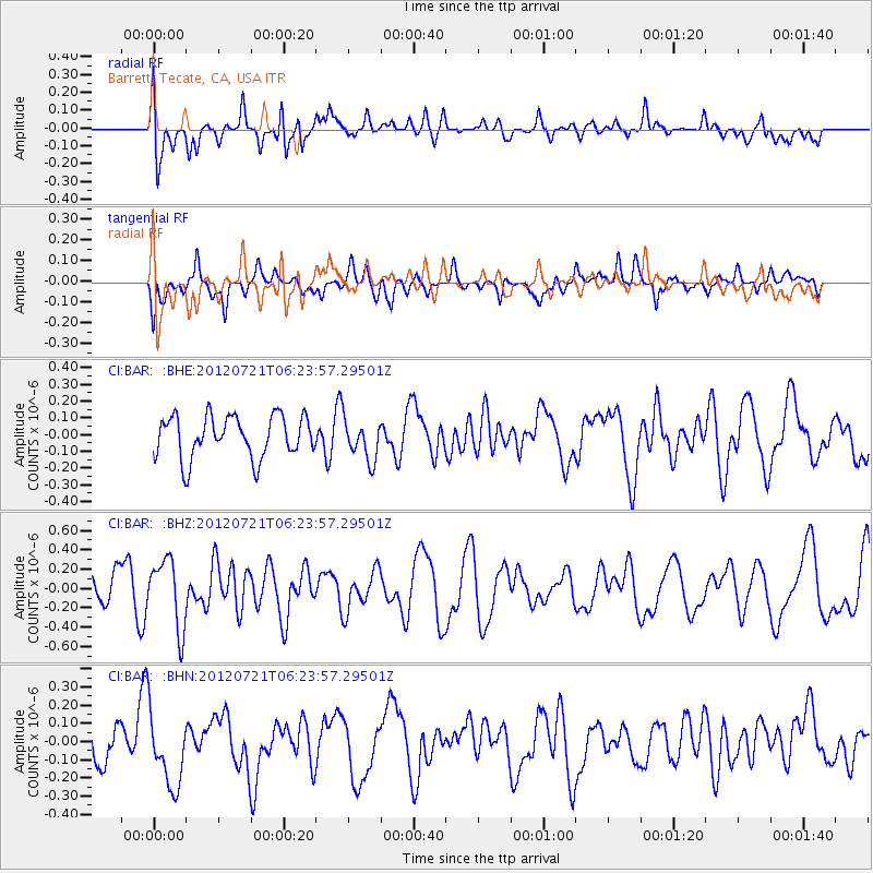
BAR Barrett, Tecate, CA, USA - Earthquake Result Viewer
*The percent match for this event was below the threshold and hence no stack was calculated.
| Earthquake location: |
Vanuatu Islands Region |
| Earthquake latitude/longitude: |
-19.2/173.8 |
| Earthquake time(UTC): |
2012/07/21 (203) 06:11:57 GMT |
| Earthquake Depth: |
10 km |
| Earthquake Magnitude: |
5.5 MB, 5.5 MS, 5.9 MW, 5.8 MW |
| Earthquake Catalog/Contributor: |
WHDF/NEIC |
|
| Network: |
CI Caltech Regional Seismic Network |
| Station: |
BAR Barrett, Tecate, CA, USA |
| Lat/Lon: |
32.68 N/116.67 W |
| Elevation: |
521 m |
|
| Distance: |
84.1 deg |
| Az: |
52.595 deg |
| Baz: |
242.902 deg |
| Ray Param: |
$rayparam |
*The percent match for this event was below the threshold and hence was not used in the summary stack. |
|
| Radial Match: |
64.73268 % |
| Radial Bump: |
400 |
| Transverse Match: |
63.861275 % |
| Transverse Bump: |
400 |
| SOD ConfigId: |
469095 |
| Insert Time: |
2013-02-22 00:26:07.602 +0000 |
| GWidth: |
2.5 |
| Max Bumps: |
400 |
| Tol: |
0.001 |
|
Signal To Noise
| Channel | StoN | STA | LTA |
| CI:BAR: :BHZ:20120721T06:23:57.29501Z | 2.085797 | 3.5599402E-7 | 1.7067529E-7 |
| CI:BAR: :BHN:20120721T06:23:57.29501Z | 1.5897069 | 2.0635322E-7 | 1.2980583E-7 |
| CI:BAR: :BHE:20120721T06:23:57.29501Z | 0.9569121 | 1.192625E-7 | 1.2463265E-7 |
| Arrivals |
| Ps | |
| PpPs | |
| PsPs/PpSs | |


