You are here: Home > Network List > TA - USArray Transportable Network (new EarthScope stations) Stations List
> Station J05D Fort Rock, OR, USA > Earthquake Result Viewer
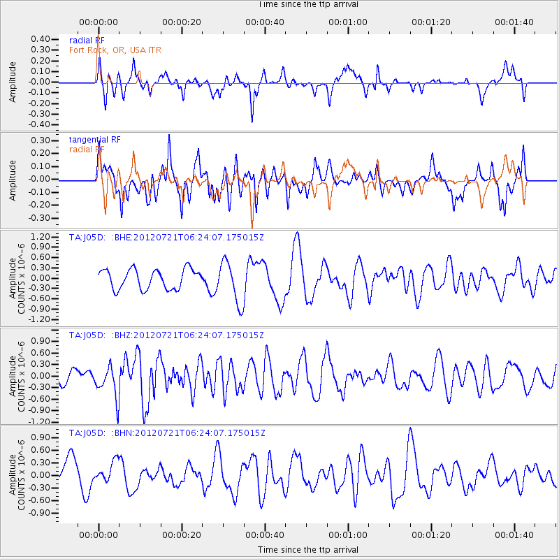
J05D Fort Rock, OR, USA - Earthquake Result Viewer
*The percent match for this event was below the threshold and hence no stack was calculated.
| Earthquake location: |
Vanuatu Islands Region |
| Earthquake latitude/longitude: |
-19.2/173.8 |
| Earthquake time(UTC): |
2012/07/21 (203) 06:11:57 GMT |
| Earthquake Depth: |
10 km |
| Earthquake Magnitude: |
5.5 MB, 5.5 MS, 5.9 MW, 5.8 MW |
| Earthquake Catalog/Contributor: |
WHDF/NEIC |
|
| Network: |
TA USArray Transportable Network (new EarthScope stations) |
| Station: |
J05D Fort Rock, OR, USA |
| Lat/Lon: |
43.28 N/121.23 W |
| Elevation: |
1541 m |
|
| Distance: |
86.1 deg |
| Az: |
41.55 deg |
| Baz: |
239.141 deg |
| Ray Param: |
$rayparam |
*The percent match for this event was below the threshold and hence was not used in the summary stack. |
|
| Radial Match: |
42.38285 % |
| Radial Bump: |
314 |
| Transverse Match: |
55.24843 % |
| Transverse Bump: |
400 |
| SOD ConfigId: |
469095 |
| Insert Time: |
2013-02-22 00:28:09.675 +0000 |
| GWidth: |
2.5 |
| Max Bumps: |
400 |
| Tol: |
0.001 |
|
Signal To Noise
| Channel | StoN | STA | LTA |
| TA:J05D: :BHZ:20120721T06:24:07.175015Z | 2.1865742 | 4.1228498E-7 | 1.8855295E-7 |
| TA:J05D: :BHN:20120721T06:24:07.175015Z | 0.8757961 | 2.3730078E-7 | 2.709544E-7 |
| TA:J05D: :BHE:20120721T06:24:07.175015Z | 2.2333815 | 6.3457503E-7 | 2.8413194E-7 |
| Arrivals |
| Ps | |
| PpPs | |
| PsPs/PpSs | |


