You are here: Home > Network List > TA - USArray Transportable Network (new EarthScope stations) Stations List
> Station O03E Paynes Creek, CA, USA > Earthquake Result Viewer
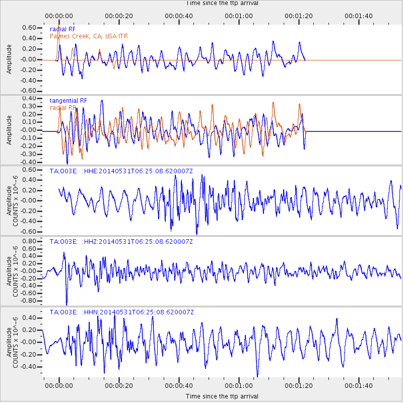
O03E Paynes Creek, CA, USA - Earthquake Result Viewer
*The percent match for this event was below the threshold and hence no stack was calculated.
| Earthquake location: |
Komandorskiye Ostrova Region |
| Earthquake latitude/longitude: |
55.0/165.7 |
| Earthquake time(UTC): |
2014/05/31 (151) 06:16:56 GMT |
| Earthquake Depth: |
20 km |
| Earthquake Magnitude: |
5.5 MW |
| Earthquake Catalog/Contributor: |
ISC/ISC |
|
| Network: |
TA USArray Transportable Network (new EarthScope stations) |
| Station: |
O03E Paynes Creek, CA, USA |
| Lat/Lon: |
40.29 N/121.80 W |
| Elevation: |
967 m |
|
| Distance: |
48.8 deg |
| Az: |
75.894 deg |
| Baz: |
313.056 deg |
| Ray Param: |
$rayparam |
*The percent match for this event was below the threshold and hence was not used in the summary stack. |
|
| Radial Match: |
65.49039 % |
| Radial Bump: |
400 |
| Transverse Match: |
55.9164 % |
| Transverse Bump: |
400 |
| SOD ConfigId: |
3390531 |
| Insert Time: |
2019-04-12 02:52:15.098 +0000 |
| GWidth: |
2.5 |
| Max Bumps: |
400 |
| Tol: |
0.001 |
|
Signal To Noise
| Channel | StoN | STA | LTA |
| TA:O03E: :HHZ:20140531T06:25:08.620007Z | 2.4779942 | 2.9639975E-7 | 1.1961276E-7 |
| TA:O03E: :HHN:20140531T06:25:08.620007Z | 0.9181371 | 1.0817817E-7 | 1.17823554E-7 |
| TA:O03E: :HHE:20140531T06:25:08.620007Z | 0.95261157 | 1.4765092E-7 | 1.5499593E-7 |
| Arrivals |
| Ps | |
| PpPs | |
| PsPs/PpSs | |


