You are here: Home > Network List > UW - Pacific Northwest Regional Seismic Network Stations List
> Station HOOD Mt Hood Meadows, OR CREST BB SMO > Earthquake Result Viewer
HOOD Mt Hood Meadows, OR CREST BB SMO - Earthquake Result Viewer
*The percent match for this event was below the threshold and hence no stack was calculated.
| Earthquake location: |
Bismarck Sea |
| Earthquake latitude/longitude: |
-4.9/149.5 |
| Earthquake time(UTC): |
2012/07/22 (204) 07:02:13 GMT |
| Earthquake Depth: |
20 km |
| Earthquake Magnitude: |
5.5 MB, 5.3 MS, 5.6 MW, 5.6 MW |
| Earthquake Catalog/Contributor: |
WHDF/NEIC |
|
| Network: |
UW Pacific Northwest Regional Seismic Network |
| Station: |
HOOD Mt Hood Meadows, OR CREST BB SMO |
| Lat/Lon: |
45.32 N/121.65 W |
| Elevation: |
1520 m |
|
| Distance: |
92.6 deg |
| Az: |
44.917 deg |
| Baz: |
265.744 deg |
| Ray Param: |
$rayparam |
*The percent match for this event was below the threshold and hence was not used in the summary stack. |
|
| Radial Match: |
36.87899 % |
| Radial Bump: |
400 |
| Transverse Match: |
51.390633 % |
| Transverse Bump: |
400 |
| SOD ConfigId: |
469095 |
| Insert Time: |
2013-02-22 00:33:03.069 +0000 |
| GWidth: |
2.5 |
| Max Bumps: |
400 |
| Tol: |
0.001 |
|
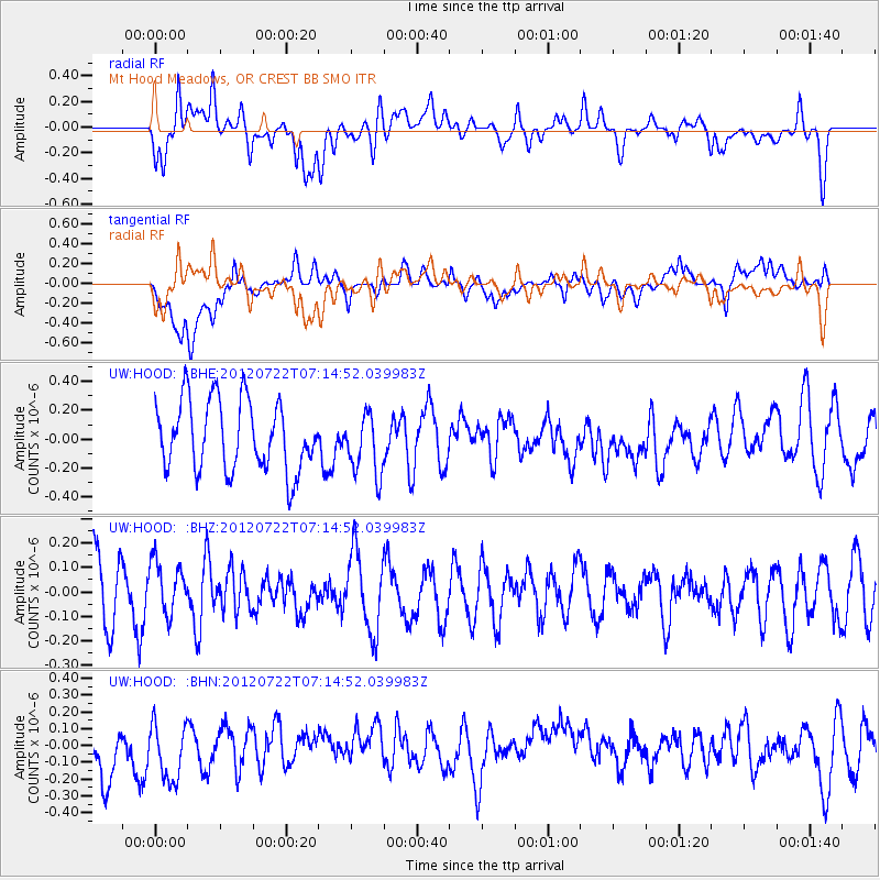
Signal To Noise
| Channel | StoN | STA | LTA |
| UW:HOOD: :BHZ:20120722T07:14:52.039983Z | 0.72909933 | 1.0635858E-7 | 1.4587665E-7 |
| UW:HOOD: :BHN:20120722T07:14:52.039983Z | 1.1474864 | 2.1054655E-7 | 1.83485E-7 |
| UW:HOOD: :BHE:20120722T07:14:52.039983Z | 0.87111443 | 2.097951E-7 | 2.408353E-7 |
| Arrivals |
| Ps | |
| PpPs | |
| PsPs/PpSs | |


