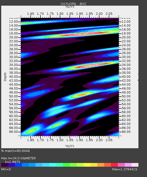
FUORN Ofenpass-Fuorn - Earthquake Result Viewer

Earthquake location: Northern Sumatra, Indonesia
Earthquake latitude/longitude: 2.7/96.0
Earthquake time(UTC): 2012/07/25 (207) 00:27:45 GMT
Earthquake Depth: 22 km
Earthquake Magnitude: 5.9 MB, 6.5 MS, 6.4 MW, 6.3 MW
Earthquake Catalog/Contributor: WHDF/NEIC
Network: CH Switzerland Seismological Network
Station: FUORN Ofenpass-Fuorn
Lat/Lon: 46.62 N/10.26 E
Elevation: 2333 m
Distance: 85.1 deg
Az: 316.38 deg
Baz: 91.202 deg
Ray Param: 0.044953406
Estimated Moho Depth: 34.0 km
Estimated Crust Vp/Vs: 1.97
Assumed Crust Vp: 6.35 km/s
Estimated Crust Vs: 3.227 km/s
Estimated Crust Poisson's Ratio: 0.33
Radial Match: 90.9446 %
Radial Bump: 400
Transverse Match: 80.07407 %
Transverse Bump: 400
SOD ConfigId: 469095
Insert Time: 2013-02-22 00:35:29.028 +0000
GWidth: 2.5
Max Bumps: 400
Tol: 0.001

Signal To Noise

ChannelStoNSTALTA
CH:FUORN: :BHZ:20120725T00:39:48.176016Z11.3674958.9384474E-77.863164E-8
CH:FUORN: :BHN:20120725T00:39:48.166982Z1.69121471.5888443E-79.394693E-8
CH:FUORN: :BHE:20120725T00:39:48.158987Z3.30292633.108093E-79.410119E-8
Arrivals
Ps5.3 SECOND
PpPs16 SECOND
PsPs/PpSs21 SECOND