You are here: Home > Network List > G - GEOSCOPE Stations List
> Station TAM Tamanrasset, Algeria > Earthquake Result Viewer
TAM Tamanrasset, Algeria - Earthquake Result Viewer
| Earthquake location: |
Xizang |
| Earthquake latitude/longitude: |
30.9/83.5 |
| Earthquake time(UTC): |
2008/08/25 (238) 13:21:58 GMT |
| Earthquake Depth: |
12 km |
| Earthquake Magnitude: |
6.2 MB, 6.5 MS, 6.7 MW, 6.7 MW |
| Earthquake Catalog/Contributor: |
WHDF/NEIC |
|
| Network: |
G GEOSCOPE |
| Station: |
TAM Tamanrasset, Algeria |
| Lat/Lon: |
22.79 N/5.53 E |
| Elevation: |
1377 m |
|
| Distance: |
68.8 deg |
| Az: |
284.472 deg |
| Baz: |
64.406 deg |
| Ray Param: |
0.056071874 |
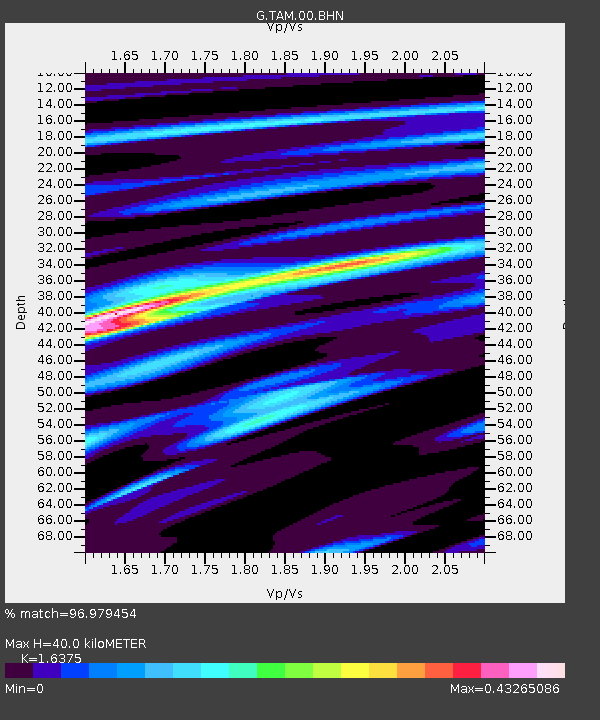
| Estimated Moho Depth: |
40.0 km |
| Estimated Crust Vp/Vs: |
1.64 |
| Assumed Crust Vp: |
6.61 km/s |
| Estimated Crust Vs: |
4.037 km/s |
| Estimated Crust Poisson's Ratio: |
0.20 |
|
| Radial Match: |
96.979454 % |
| Radial Bump: |
205 |
| Transverse Match: |
77.7485 % |
| Transverse Bump: |
400 |
| SOD ConfigId: |
2504 |
| Insert Time: |
2010-02-27 00:23:42.818 +0000 |
| GWidth: |
2.5 |
| Max Bumps: |
400 |
| Tol: |
0.001 |
|
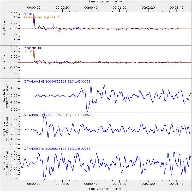
Signal To Noise
| Channel | StoN | STA | LTA |
| G:TAM:00:BHN:20080825T13:32:31.450005Z | 12.687159 | 1.223561E-6 | 9.64409E-8 |
| G:TAM:00:BHE:20080825T13:32:31.450005Z | 2.8932273 | 2.6401526E-7 | 9.125285E-8 |
| G:TAM:00:BHZ:20080825T13:32:31.450005Z | 6.17141 | 5.263518E-7 | 8.528874E-8 |
| Arrivals |
| Ps | 4.0 SECOND |
| PpPs | 15 SECOND |
| PsPs/PpSs | 19 SECOND |


