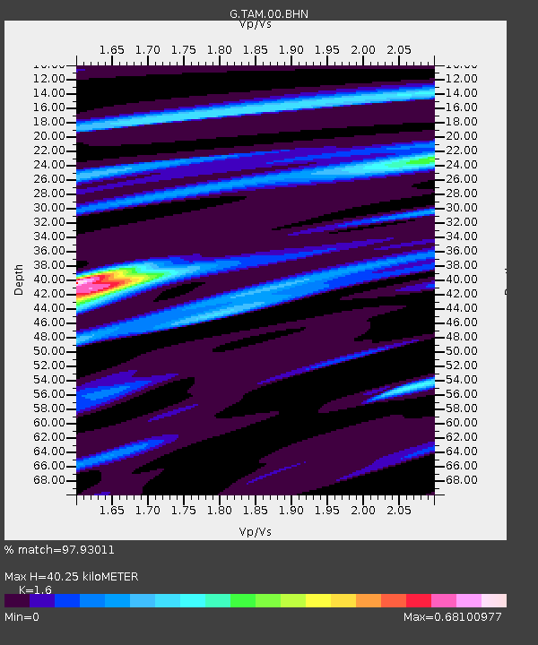
TAM Tamanrasset, Algeria - Earthquake Result Viewer
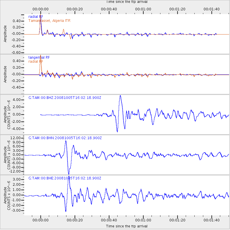
Earthquake location: Tajikistan-Xinjiang Border Reg.
Earthquake latitude/longitude: 39.5/73.8
Earthquake time(UTC): 2008/10/05 (279) 15:52:49 GMT
Earthquake Depth: 27 km
Earthquake Magnitude: 6.4 MB, 6.9 MS, 6.6 MW, 6.6 MW
Earthquake Catalog/Contributor: WHDF/NEIC
Network: G GEOSCOPE
Station: TAM Tamanrasset, Algeria
Lat/Lon: 22.79 N/5.53 E
Elevation: 1377 m
Distance: 59.5 deg
Az: 275.431 deg
Baz: 56.537 deg
Ray Param: 0.06212954
Estimated Moho Depth: 40.25 km
Estimated Crust Vp/Vs: 1.60
Assumed Crust Vp: 6.61 km/s
Estimated Crust Vs: 4.131 km/s
Estimated Crust Poisson's Ratio: 0.18
Radial Match: 97.93011 %
Radial Bump: 307
Transverse Match: 91.00869 %
Transverse Bump: 400
SOD ConfigId: 2556
Insert Time: 2010-02-27 00:23:49.214 +0000
GWidth: 2.5
Max Bumps: 400
Tol: 0.001

Signal To Noise

ChannelStoNSTALTA
G:TAM:00:BHN:20081005T16:02:18.900Z2.12903982.034195E-79.554519E-8
G:TAM:00:BHE:20081005T16:02:18.900Z1.70683238.447925E-84.9494755E-8
G:TAM:00:BHZ:20081005T16:02:18.900Z2.82523011.0263702E-73.6328725E-8
Arrivals
Ps3.9 SECOND
PpPs15 SECOND
PsPs/PpSs19 SECOND