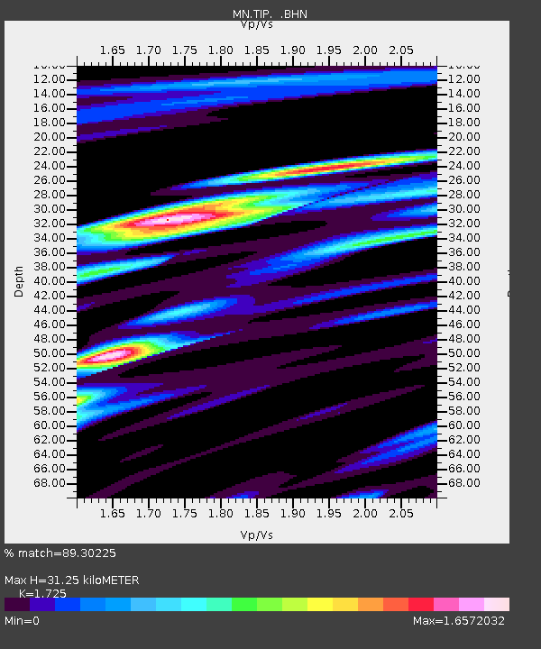
TIP Timpagrande, Italy - Earthquake Result Viewer
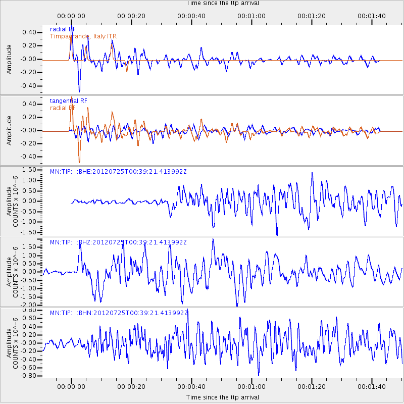
Earthquake location: Northern Sumatra, Indonesia
Earthquake latitude/longitude: 2.7/96.0
Earthquake time(UTC): 2012/07/25 (207) 00:27:45 GMT
Earthquake Depth: 22 km
Earthquake Magnitude: 5.9 MB, 6.5 MS, 6.4 MW, 6.3 MW
Earthquake Catalog/Contributor: WHDF/NEIC
Network: MN MEDNET Project
Station: TIP Timpagrande, Italy
Lat/Lon: 39.18 N/16.76 E
Elevation: 789 m
Distance: 80.0 deg
Az: 309.149 deg
Baz: 94.681 deg
Ray Param: 0.048561454
Estimated Moho Depth: 31.25 km
Estimated Crust Vp/Vs: 1.73
Assumed Crust Vp: 6.1 km/s
Estimated Crust Vs: 3.536 km/s
Estimated Crust Poisson's Ratio: 0.25
Radial Match: 89.30225 %
Radial Bump: 400
Transverse Match: 81.8364 %
Transverse Bump: 400
SOD ConfigId: 469095
Insert Time: 2013-02-22 00:38:27.053 +0000
GWidth: 2.5
Max Bumps: 400
Tol: 0.001

Signal To Noise

ChannelStoNSTALTA
MN:TIP: :BHZ:20120725T00:39:21.413992Z9.2221146.535524E-77.0867955E-8
MN:TIP: :BHN:20120725T00:39:21.413992Z1.18871277.536537E-86.3400826E-8
MN:TIP: :BHE:20120725T00:39:21.413992Z4.9950162.9558387E-75.917576E-8
Arrivals
Ps3.8 SECOND
PpPs14 SECOND
PsPs/PpSs17 SECOND