You are here: Home > Network List > TJ - Tajikistan National Seismic Network Stations List
> Station GARM Garm, Tajikistan > Earthquake Result Viewer
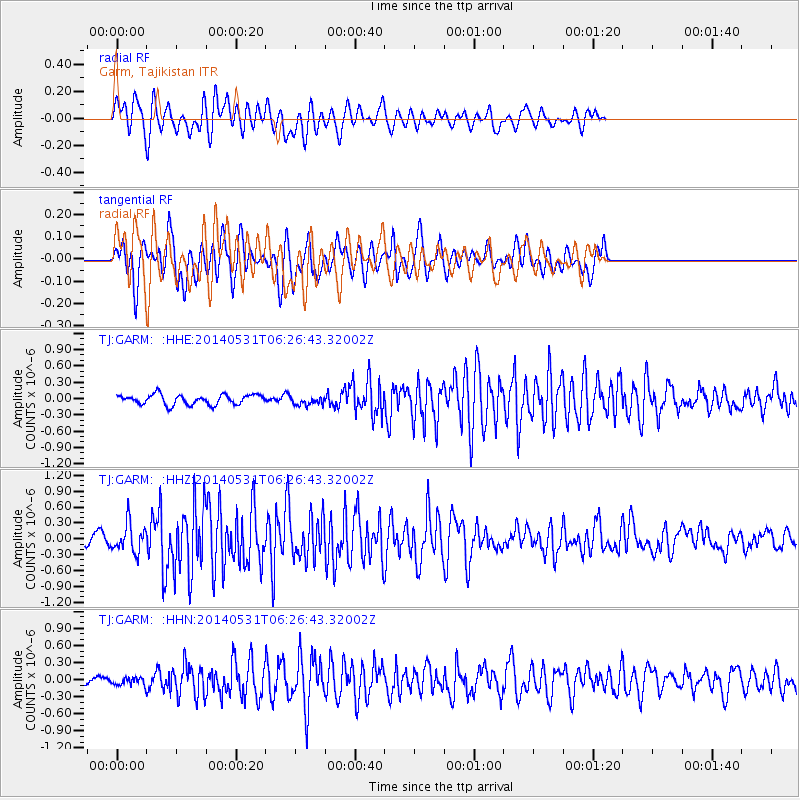
GARM Garm, Tajikistan - Earthquake Result Viewer
*The percent match for this event was below the threshold and hence no stack was calculated.
| Earthquake location: |
Komandorskiye Ostrova Region |
| Earthquake latitude/longitude: |
55.0/165.7 |
| Earthquake time(UTC): |
2014/05/31 (151) 06:16:56 GMT |
| Earthquake Depth: |
20 km |
| Earthquake Magnitude: |
5.5 MW |
| Earthquake Catalog/Contributor: |
ISC/ISC |
|
| Network: |
TJ Tajikistan National Seismic Network |
| Station: |
GARM Garm, Tajikistan |
| Lat/Lon: |
39.00 N/70.32 E |
| Elevation: |
1305 m |
|
| Distance: |
62.0 deg |
| Az: |
298.478 deg |
| Baz: |
40.546 deg |
| Ray Param: |
$rayparam |
*The percent match for this event was below the threshold and hence was not used in the summary stack. |
|
| Radial Match: |
67.435646 % |
| Radial Bump: |
400 |
| Transverse Match: |
68.92372 % |
| Transverse Bump: |
400 |
| SOD ConfigId: |
3390531 |
| Insert Time: |
2019-04-12 02:53:27.035 +0000 |
| GWidth: |
2.5 |
| Max Bumps: |
400 |
| Tol: |
0.001 |
|
Signal To Noise
| Channel | StoN | STA | LTA |
| TJ:GARM: :HHZ:20140531T06:26:43.32002Z | 3.4233344 | 2.7447965E-7 | 8.017904E-8 |
| TJ:GARM: :HHN:20140531T06:26:43.32002Z | 1.1651975 | 6.07627E-8 | 5.2147985E-8 |
| TJ:GARM: :HHE:20140531T06:26:43.32002Z | 0.8870828 | 8.060696E-8 | 9.086745E-8 |
| Arrivals |
| Ps | |
| PpPs | |
| PsPs/PpSs | |


