You are here: Home > Network List > AK - Alaska Regional Network Stations List
> Station WRH Wood River Hill > Earthquake Result Viewer
WRH Wood River Hill - Earthquake Result Viewer
| Earthquake location: |
Solomon Islands |
| Earthquake latitude/longitude: |
-9.7/159.7 |
| Earthquake time(UTC): |
2012/07/25 (207) 11:20:27 GMT |
| Earthquake Depth: |
20 km |
| Earthquake Magnitude: |
6.4 MB, 6.5 MS, 6.4 MW, 6.3 MW |
| Earthquake Catalog/Contributor: |
WHDF/NEIC |
|
| Network: |
AK Alaska Regional Network |
| Station: |
WRH Wood River Hill |
| Lat/Lon: |
64.47 N/148.09 W |
| Elevation: |
343 m |
|
| Distance: |
83.6 deg |
| Az: |
20.148 deg |
| Baz: |
231.601 deg |
| Ray Param: |
0.046042506 |
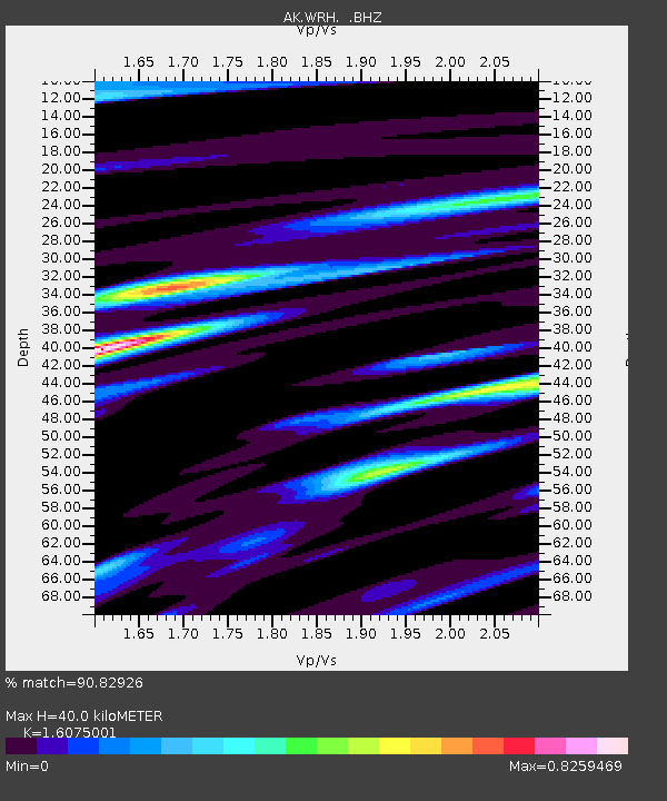
| Estimated Moho Depth: |
40.0 km |
| Estimated Crust Vp/Vs: |
1.61 |
| Assumed Crust Vp: |
6.566 km/s |
| Estimated Crust Vs: |
4.085 km/s |
| Estimated Crust Poisson's Ratio: |
0.18 |
|
| Radial Match: |
90.82926 % |
| Radial Bump: |
400 |
| Transverse Match: |
81.78771 % |
| Transverse Bump: |
400 |
| SOD ConfigId: |
469095 |
| Insert Time: |
2013-02-22 00:40:45.002 +0000 |
| GWidth: |
2.5 |
| Max Bumps: |
400 |
| Tol: |
0.001 |
|

Signal To Noise
| Channel | StoN | STA | LTA |
| AK:WRH: :BHZ:20120725T11:32:22.508027Z | 14.393123 | 7.700261E-7 | 5.3499583E-8 |
| AK:WRH: :BHN:20120725T11:32:22.508027Z | 7.087717 | 2.2050088E-7 | 3.1110282E-8 |
| AK:WRH: :BHE:20120725T11:32:22.508027Z | 3.927238 | 1.951838E-7 | 4.9700017E-8 |
| Arrivals |
| Ps | 3.8 SECOND |
| PpPs | 15 SECOND |
| PsPs/PpSs | 19 SECOND |


