You are here: Home > Network List > US - United States National Seismic Network Stations List
> Station DGMT Dagmar, Montana, USA > Earthquake Result Viewer
DGMT Dagmar, Montana, USA - Earthquake Result Viewer
*The percent match for this event was below the threshold and hence no stack was calculated.
| Earthquake location: |
Komandorskiye Ostrova Region |
| Earthquake latitude/longitude: |
55.0/165.7 |
| Earthquake time(UTC): |
2014/05/31 (151) 06:16:56 GMT |
| Earthquake Depth: |
20 km |
| Earthquake Magnitude: |
5.5 MW |
| Earthquake Catalog/Contributor: |
ISC/ISC |
|
| Network: |
US United States National Seismic Network |
| Station: |
DGMT Dagmar, Montana, USA |
| Lat/Lon: |
48.47 N/104.20 W |
| Elevation: |
0.0 m |
|
| Distance: |
52.5 deg |
| Az: |
57.06 deg |
| Baz: |
313.39 deg |
| Ray Param: |
$rayparam |
*The percent match for this event was below the threshold and hence was not used in the summary stack. |
|
| Radial Match: |
50.47502 % |
| Radial Bump: |
400 |
| Transverse Match: |
53.0578 % |
| Transverse Bump: |
400 |
| SOD ConfigId: |
3390531 |
| Insert Time: |
2019-04-12 02:54:00.793 +0000 |
| GWidth: |
2.5 |
| Max Bumps: |
400 |
| Tol: |
0.001 |
|
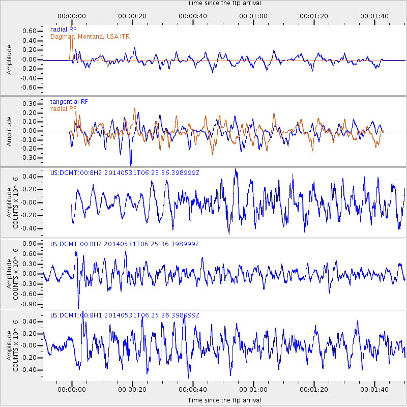
Signal To Noise
| Channel | StoN | STA | LTA |
| US:DGMT:00:BHZ:20140531T06:25:36.398999Z | 2.8932195 | 3.824313E-7 | 1.3218191E-7 |
| US:DGMT:00:BH1:20140531T06:25:36.398999Z | 1.9438412 | 2.6563706E-7 | 1.3665574E-7 |
| US:DGMT:00:BH2:20140531T06:25:36.398999Z | 1.6843371 | 2.115917E-7 | 1.2562313E-7 |
| Arrivals |
| Ps | |
| PpPs | |
| PsPs/PpSs | |


