You are here: Home > Network List > AK - Alaska Regional Network Stations List
> Station WAX Waxell Ridge, AK, USA > Earthquake Result Viewer
WAX Waxell Ridge, AK, USA - Earthquake Result Viewer
| Earthquake location: |
Solomon Islands |
| Earthquake latitude/longitude: |
-9.7/159.7 |
| Earthquake time(UTC): |
2012/07/25 (207) 11:20:27 GMT |
| Earthquake Depth: |
20 km |
| Earthquake Magnitude: |
6.4 MB, 6.5 MS, 6.4 MW, 6.3 MW |
| Earthquake Catalog/Contributor: |
WHDF/NEIC |
|
| Network: |
AK Alaska Regional Network |
| Station: |
WAX Waxell Ridge, AK, USA |
| Lat/Lon: |
60.45 N/142.85 W |
| Elevation: |
1003 m |
|
| Distance: |
83.2 deg |
| Az: |
24.876 deg |
| Baz: |
236.785 deg |
| Ray Param: |
0.046317916 |
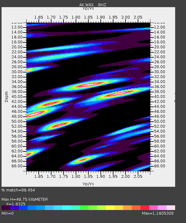
| Estimated Moho Depth: |
46.75 km |
| Estimated Crust Vp/Vs: |
1.63 |
| Assumed Crust Vp: |
6.566 km/s |
| Estimated Crust Vs: |
4.022 km/s |
| Estimated Crust Poisson's Ratio: |
0.20 |
|
| Radial Match: |
86.454 % |
| Radial Bump: |
400 |
| Transverse Match: |
86.42988 % |
| Transverse Bump: |
400 |
| SOD ConfigId: |
469095 |
| Insert Time: |
2013-02-22 00:41:05.189 +0000 |
| GWidth: |
2.5 |
| Max Bumps: |
400 |
| Tol: |
0.001 |
|

Signal To Noise
| Channel | StoN | STA | LTA |
| AK:WAX: :BHZ:20120725T11:32:20.527986Z | 4.7207103 | 3.505752E-7 | 7.4263234E-8 |
| AK:WAX: :BHN:20120725T11:32:20.527986Z | 1.9926609 | 1.5481562E-7 | 7.769291E-8 |
| AK:WAX: :BHE:20120725T11:32:20.527986Z | 1.9531732 | 1.5359751E-7 | 7.8639985E-8 |
| Arrivals |
| Ps | 4.6 SECOND |
| PpPs | 18 SECOND |
| PsPs/PpSs | 23 SECOND |


